The Great Glen Fault is a strike-slip fault that runs through the Great Glen in Scotland. The fault is mostly inactive today, but occasional moderate tremors have been recorded over the past 150 years.
Location
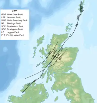
Aligned northeast to southwest, the Great Glen Fault extends further southwest in a straight line through Loch Linnhe and the Firth of Lorne, and then on into northwestern Ireland, directly through Lough Swilly, Donegal Bay and Clew Bay as the Leannan Fault. To the northeast the fault connects to the Walls Boundary Fault and the associated Melby Fault and Nestings Fault, before becoming obscured by the effects of Mesozoic rifting to the north of Shetland.[1]
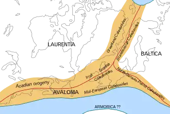
The fault continues on the North American side of the North Atlantic Ocean, but is no longer part of a contiguous fault, as the complete fault was broken when the Mid-Atlantic Ridge formed 200 million years ago. The North American side of the fault runs through the length of northwestern Newfoundland, Canada, as the Cabot Fault (Long Range Fault) and on into the Gulf of St. Lawrence.[2] It is at least 300 miles (480 km) long.
History


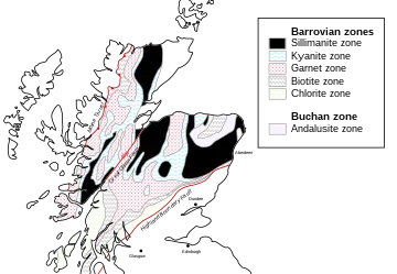
The Great Glen Fault has a long movement history. It formed towards the end of the Caledonian orogeny associated with the collision between the Laurentia and Baltic tectonic plates at the end of the Silurian continuing into the Early Devonian (likely age range 430–390 Ma (million years)). The movement at that time was sinistral (left-lateral), the same as the closely related set of faults sub-parallel to the main part of the Great Glen Fault, which include the Strathconon Fault and Strathglass Faults to the northwest and the Laggan Fault, Tyndrum Fault, and Ericht-Laidon Fault to the southeast.[1] The second main phase of movement was during the Carboniferous, this time with a dextral sense.
The exact timing is uncertain, but associated folds within the Devonian are cut by members of the Late Carboniferous to Early Permian dyke swarm. The Great Glen Fault had its final phase of movement during the Late Cretaceous to Early Tertiary. The displacement is estimated to be 64 miles (104 km).[3]
Erosion along the fault zone during Quaternary glaciation formed Loch Ness.
The fault is mostly inactive today, but occasional moderate tremors have been recorded over the past 150 years which has meant that seismic buffers are built into the Kessock Bridge carrying the A9 road out of Inverness. None of the modern day infrastructure has been affected by the tremors; the most recent significant event to affect Inverness and the surrounding area occurred in September 1901 and was approximately a 5.0 magnitude quake.[4] In the 19th century, a boat canal known as the Caledonian Canal was dug through the Great Glen; the canal is still used today.
See also
References
- 1 2 Stewart, M.; Strachan, R.A.; Holdsworth, R.E. (1999). "Structure and early kinematic history of the Great Glen Fault Zone, Scotland". Tectonics. 18 (2): 326–342. Bibcode:1999Tecto..18..326S. doi:10.1029/1998TC900033.
- ↑ Redfern, Ron (November 2001). Origins: The Evolution of Continents, Oceans and Life. University of Oklahoma Press. pp. 82–83. ISBN 978-0-8061-3359-1.
- ↑ "Great Glen Fault". Gazetteer for Scotland. 2016.
- ↑ Piccardi, Luigi. (2014). Post-glacial activity and earthquakes of the Great Glen Fault (Scotland). Memorie Descrittive della Carta Geologica d’Italia. XCVI. 431-446.
Further reading
- Dewey, John F.; Kennedy, Michael J.; Kidd, William S.F. (1983). "A geotraverse through the Appalachians of northern Newfoundland" (PDF). In Rast, Nicholas; Delany, Frances M. (eds.). Profiles of Orogenic Belts. Geodynamics Series. Vol. 10. American Geophysical Union.
- Dewey, J. F. (2005). "Orogeny can be very short". Proceedings of the National Academy of Sciences of the United States of America. 102 (43): 15286–15293. Bibcode:2005PNAS..10215286D. doi:10.1073/pnas.0505516102. PMC 1266104. PMID 16126898.
- Rogers, D. A.; Marshall, J. E. A.; Astin, T. R. (1989). "Devonian and later movements on the Great Glen fault system, Scotland". Journal of the Geological Society. 146 (3): 369–372. doi:10.1144/gsjgs.146.3.0369. S2CID 128498128.
- Stewart, M.; Strachan, R. A.; Martin, M. W.; Holdsworth, R. E. (2001). "Constraints on early sinistral displacements along the Great Glen Fault Zone, Scotland: structural setting, U-Pb geochronology and emplacement of the syn-tectonic Clunes tonalite". Journal of the Geological Society. 158 (5): 821–830. Bibcode:2001JGSoc.158..821S. doi:10.1144/jgs.158.5.821. S2CID 129801878.
- Stephenson, D.; Gould, D. (1995). British Regional Geology. The Grampian Highlands (4 ed.). Her Majesty's Stationery Office, London: British Geological Survey.
- Trewin, N. H., ed. (2002). The Geology of Scotland. The Geological Society, London.
- Wilson, Tuzo (14 July 1962). "Cabot Fault, An Appalachian Equivalent of the San Andreas and Great Glen Faults and some Implications for Continental Displacement". Nature. 195 (4837): 135–138. Bibcode:1962Natur.195..135W. doi:10.1038/195135a0. S2CID 4289725.
- Piccardi, Luigi (2014). "Post-glacial activity and earthquakes of the Great Glen Fault (Scotland)" (PDF). Memorie Descrittive della Carta Geologica d'Italia. 96: 431–446.