| Waputik Mountains | |
|---|---|
%2526_Mt_Chephren_(3307m)_(7897964306).jpg.webp) Howse Peak & Mount Chephren | |
| Highest point | |
| Peak | Howse Peak |
| Elevation | 3,295 m (10,810 ft) |
| Listing | |
| Coordinates | 51°48′49″N 116°40′52″W / 51.81361°N 116.68111°W[1] |
| Dimensions | |
| Length | 61 km (38 mi) N-S[2] |
| Width | 40 km (25 mi) E-W[2] |
| Area | 1,069 km2 (413 sq mi)[3] |
| Geography | |
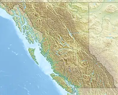  | |
| Country | Canada |
| Provinces | British Columbia and Alberta |
| Range coordinates | 51°35′N 116°25′W / 51.583°N 116.417°W[4] |
| Parent range | Canadian Rockies |
| Borders on | Conway Group |
| Topo map | NTS 82N10 Blaeberry River |

Epaulette Mountain
The Waputik Mountains are a mountain range of the Canadian Rockies, located on the Continental Divide between Banff and Yoho National Park. Covering an area of 1,069 square kilometres (413 sq mi),[3] the range is located west of the Howse, Blaeberry and Amiskwi Rivers and east of the Bow and Mistaya Rivers and south to Kicking Horse Pass.[5] Named in 1884 by George M. Dawson, "waputik" is the Stoney Indian word for white goat.[5]
Many of the highest peaks of the range are heavily glaciated as they sit within the Waputik and Wapta Icefields. The range is further divided into the President Range and Waputik Range
Mountains and Peaks
This range includes the following mountains and peaks:[6]
| Name | Elevation | Prominence | FA | Coordinates | ||
|---|---|---|---|---|---|---|
| m | ft | m | ft | |||
| Howse Peak | 10,810
style="text-align:right;" data-sort-value="7003122700000000000"|1,227 |
4,026 | 1902 | 51°48'50"N, 116°40'52"W | ||
| Mount Balfour | 10,735
style="text-align:right;" data-sort-value="7002934000000000000"|934 |
3,064 | 1898 | 51°33'55"N, 116°27'58"W | ||
| Mount Chephren | 10,715
style="text-align:right;" data-sort-value="7002443000000000000"|443 |
1,453 | 1913 | 51°50'25"N, 116°40'59"W | ||
| White Pyramid | 10,561
style="text-align:right;" data-sort-value="7002236000000000000"|236 |
774 | 1939 | 51°50'8"N, 116°41'40"W | ||
| Mount Baker | 10,407
style="text-align:right;" data-sort-value="7002480000000000000"|480 |
1,570 | 1923 | 51°39'55"N, 116°35'52"W | ||
| Mount Gordon | 10,371
style="text-align:right;" data-sort-value="7002471000000000000"|471 |
1,545 | 1897 | 51°36'22"N, 116°30'48"W | ||
| Mont des Poilus | 10,371
style="text-align:right;" data-sort-value="7002466000000000000"|466 |
1,529 | 1901 | 51°35'42"N, 116°36'29"W | ||
| Mount Sarbach | 10,351
style="text-align:right;" data-sort-value="7002412000000000000"|412 |
1,352 | 1897 | 51°52'35"N, 116°46'0"W | ||
| Mount Olive | 10,270
style="text-align:right;" data-sort-value="7002146000000000000"|146 |
479 | 1927 | 51°36'40"N, 116°29'30"W | ||
| Mount Collie | 10,223
style="text-align:right;" data-sort-value="7002423000000000000"|423 |
1,388 | 1901 | 51°37'2"N, 116°35'31"W | ||
| Kaufmann Peaks | 10,200
style="text-align:right;" data-sort-value="7002184000000000000"|184 |
604 | 1927 | 51°53'0"N, 116°45'0"W | ||
| Epaulette Mountain | 10,151
style="text-align:right;" data-sort-value="7002259000000000000"|259 |
850 | 1924 | 51°51'57"N, 116°44'6"W | ||
| Ayesha Peak | 10,056
style="text-align:right;" data-sort-value="7002287000000000000"|287 |
942 | 1939 | 51°38'22"N, 116°0'19"W | ||
| Mount Thompson | 10,056
style="text-align:right;" data-sort-value="7002369000000000000"|369 |
1,211 | 1898 | 51°39'50"N, 116°31'22"W | ||
| Mount Rhondda | 10,046
style="text-align:right;" data-sort-value="7002102000000000000"|102 |
335 | 1923 | 51°38'36"N, 116°33'40"W | ||
| Crowfoot Mountain | 10,010
style="text-align:right;" data-sort-value="7002355000000000000"|355 |
1,165 | 1950 | 51°37'30"N, 116°25'59"W | ||
| Trapper Peak | 9,888
style="text-align:right;" data-sort-value="7002128000000000000"|128 |
420 | 1933 | 51°40'38"N, 116°35'27"W | ||
| Mount Synge | 9,751
style="text-align:right;" data-sort-value="7001470000000000000"|47 |
154 | 1952 | 51°48'20"N, 116°39'44"W | ||
| Peyto Peak | 9,740
style="text-align:right;" data-sort-value="7002220000000000000"|220 |
720 | 1933 | 51°41'2"N, 116°33'56"W | ||
| St. Nicholas Peak | 9,639
style="text-align:right;" data-sort-value="7001380000000000000"|38 |
125 | 1930 | 51°37'40"N, 116°30'9"W | ||
| Mount Jimmy Simpson | 9,731
style="text-align:right;" data-sort-value="7002251000000000000"|251 |
823 | 1897 | 51°41'8"N, 116°30'17"W | ||
| Bow Peak | 9,320
style="text-align:right;" data-sort-value="7002493000000000000"|493 |
1,617 | 51°37'35"N, 116°22'45"W | |||
References
- ↑ "Howse Peak". BC Geographical Names. Retrieved 2023-07-15.
- 1 2 "Waputik Mountains". Peakbagger.com. Retrieved 2013-06-08.
- 1 2 "Waputik Mountains". bivouac.com. Retrieved 2013-06-08.
- ↑ "Waputik Mountains". Geographical Names Data Base. Natural Resources Canada. Retrieved 2019-07-12.
- 1 2 "Waputik Mountains". BC Geographical Names. Retrieved 2013-06-08.
- ↑ Bow Lake and Saskatchewan Crossing (Map) (2nd ed.). Cochrane, AB: Gem Trek Publishing Ltd.
This article is issued from Wikipedia. The text is licensed under Creative Commons - Attribution - Sharealike. Additional terms may apply for the media files.