Way Kanan Regency
Kabupaten Way Kanan | |
|---|---|
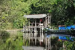 Way Kanan River Camp | |
 Coat of arms | |
| Motto(s): Ramik Ragom (Many and various) | |
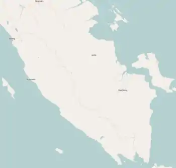
 Location within Lampung | |
| Coordinates: 4°26′49″S 104°31′39″E / 4.4470°S 104.5275°E | |
| Country | Indonesia |
| Province | Lampung |
| Regency seat | Blambangan Umpu |
| Government | |
| • Regent | Raden Adipati Surya |
| • Vice Regent | Edward Antony |
| Area | |
| • Total | 3,921.63 km2 (1,514.15 sq mi) |
| Population (mid 2022 estimate)[1] | |
| • Total | 481,036 |
| • Density | 120/km2 (320/sq mi) |
| Time zone | UTC+7 (IWST) |
| Area code | (+62) 723 |
| Website | waykanankab |

Way Kanan Regency is a landlocked regency (kabupaten) of Lampung Province, Sumatra, Indonesia. It was created on 20 April 1999 from what were formerly the northern districts of North Lampung Regency. It has an area of 3,921.63 km2 and had a population of 406,123 at the 2010 census[2] and 473,575 at the 2020 census;[3] the official estimate as at mid 2022 was 481,036.[1] The administrative centre lies at the town of Blambangan Umpu.
Administrative districts
At the time of the 2010 and 2020 Censuses, the regency was divided into fourteen districts (kecamatan), but subsequently a fifteenth district (Umpu Semenguk) was created from part of the Blambangan Umpu District. All fifteen districts are listed below with their areas and their populations at the 2010 census[2] and the 2020 census,[3] together with the official estimates as at mid 2022.[1] The table also includes the locations of the district administrative centres, the number of administrative villages in each district (totaling 224 rural desa and 8 urban kelurahan), and its post code.
| Kode Wilayah | Name of District (kecamatan) | Area in km2 | Pop'n 2010 census | Pop'n 2020 census | Pop'n mid 2022 estimate | Admin centre | No. of villages | Post code |
|---|---|---|---|---|---|---|---|---|
| 18.08.03 | Banjit | 331.60 | 42,270 | 45,945 | 46,270 | Pasar Banjit | 20 (a) | 34766 |
| 18.08.04 | Baradatu | 152.03 | 37,757 | 43,787 | 44,420 | Tiuh Balak Pasar | 27 (b) | 34761 |
| 18.08.10 | Gunung Labuhan | 115.22 | 26,906 | 31,044 | 31,460 | Gunung Labuhan | 21 | 34768 |
| 18.08.02 | Kasui | 150.27 | 29,775 | 32,289 | 32,650 | Jaya Tinggi | 19 (a) | 34765 |
| 18.08.09 | Rebang Tangkas | 207.18 | 19,719 | 24,410 | 24,910 | Gunung Sari | 10 | 34771 |
| 18.08.01 | Blambangan Umpu | 357.09 | 54,698 | 69,218 | 37,670 | Blambangan Umpu | 13 (a) | 34764 |
| 18.08.08 | Way Tuba | 206.25 | 20,400 | 25,274 | 25,970 | Way Tuba | 13 | 34772 |
| 18.08.07 | Negeri Agung | 562.98 | 32,572 | 38,253 | 38,800 | Negeri Agung | 19 | 34773 |
| 18.08.15 | Umpu Semenguk | 334.62 | (c) | (c) | 33,220 | Negeri Baru | 13 | 34764 |
| 18.08.05 | Bahuga | 138.22 | 9,631 | 11,422 | 11,640 | Mesir Ilir | 11 | 34763 |
| 18.08.13 | Buay Bahuga | 102.04 | 19,008 | 21,016 | 21,130 | Bumi Harjo | 9 | 34767 |
| 18.08.14 | Bumi Agung | 131.75 | 23,445 | 27,881 | 28,190 | Bumi Agung | 10 | 34760 |
| 18.08.06 | Pakuan Ratu | 580.34 | 37,188 | 44,709 | 45,670 | Pakuan Ratu | 19 | 34762 |
| 18.08.11 | Negara Batin | 348.40 | 33,616 | 36,588 | 37,000 | Negara Batin | 15 | 34769 |
| 18.08.12 | Negeri Besar | 362.37 | 18,138 | 21,734 | 22,110 | Negeri Besar | 13 | 34774 |
| Totals | 3,921.63 | 406,123 | 473,575 | 481,036 | Blambangan Umpu | 232 |
Note: (a) including one kelurahan. (b) including 5 kelurahan. (c) the 2010 and 2020 populations of the new Umpu Semenguk District are included in the figures for Blambangan Umpu District, from which it was created.
References
Regencies and cities of Lampung | ||
|---|---|---|
Capital: Bandar Lampung | ||
| Regencies | ||
| Cities | ||
4°26′49″S 104°31′39″E / 4.4470°S 104.5275°E