Weichang County
| |
|---|---|
围场满族蒙古族自治县 • ᠸᡝᡳ ᠴᠠᠩ ᠮᠠᠨᠵᡠ ᠮᠣᠩᡤᠣ ᠮᡠᡴᡡᠨ ᠪᡝᠶᡝ ᡩᠠᠰᠠᡵᠠ ᡥᡳᠶᠠᠨᠸᠧᠢ ᠴᠠᠩ ᠮᠠᠨᠵᠤ ᠮᠣᠩᠭᠣᠯ ᠦᠨᠳᠦᠰᠦᠲᠡᠨ ᠤ ᠥᠪᠡᠷᠲᠡᠭᠡᠨ ᠵᠠᠰᠠᠬᠤ ᠰᠢᠶᠠᠨ Weichang Manchu and Mongol Autonomous County | |
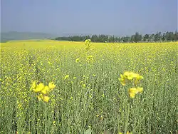
 Saihanba National Park within the county | |
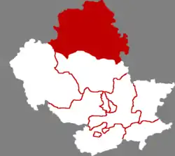
 Weichang in Chengde | |
.png.webp) Chengde in Hebei | |
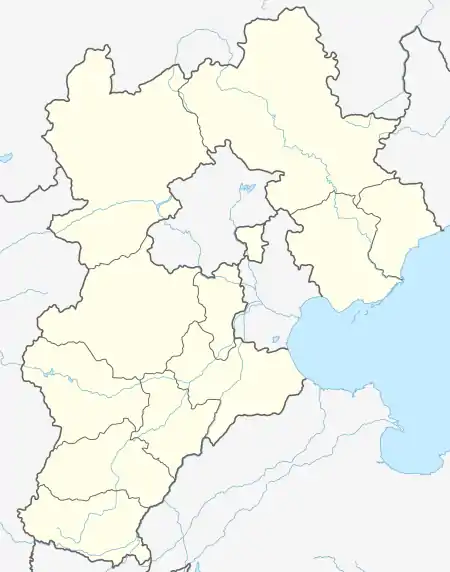
 Weichang Location of the seat in Hebei | |
| Coordinates: 41°56′20″N 117°45′36″E / 41.939°N 117.760°E | |
| Country | China |
| Province | Hebei |
| Prefecture-level city | Chengde |
| County seat | Weichang Town |
| Area | |
| • Total | 9,058 km2 (3,497 sq mi) |
| Elevation | 847 m (2,779 ft) |
| Population (2020 census)[1] | |
| • Total | 423,676 |
| • Density | 47/km2 (120/sq mi) |
| Time zone | UTC+8 (China Standard) |
| Postal code | 068400 |
| Area code | 0314 |
| Website | www |
| Weichang Manchu and Mongol Autonomous County | |||||||
|---|---|---|---|---|---|---|---|
| Chinese name | |||||||
| Simplified Chinese | 围场满族蒙古族自治县 | ||||||
| Traditional Chinese | 圍場滿族蒙古族自治縣 | ||||||
| |||||||
| Mongolian name | |||||||
| Mongolian script | ᠸᠧᠢ ᠴᠠᠩ ᠮᠠᠨᠵᠤ ᠮᠣᠩᠭᠣᠯ ᠦᠨᠳᠦᠰᠦᠲᠡᠨ ᠤ ᠥᠪᠡᠷᠲᠡᠭᠡᠨ ᠵᠠᠰᠠᠬᠤ ᠰᠢᠶᠠᠨ | ||||||
| Manchu name | |||||||
| Manchu script | ᠸᡝᡳ ᠴᠠᠩ ᠮᠠᠨᠵᡠ ᠮᠣᠩᡤᠣ ᠮᡠᡴᡡᠨ ᠪᡝᠶᡝ ᡩᠠᠰᠠᡵᠠ ᡥᡳᠶᠠᠨ | ||||||
| Möllendorff | wei cang manju monggo mukūn beye dasangga siyan | ||||||
Weichang Manchu and Mongol Autonomous County (Chinese: 围场满族蒙古族自治县) is a Manchu and Mongol autonomous county located in far northeastern Hebei province, China. It lies under the administration of Chengde City, and is the northernmost county of the province, bordering Inner Mongolia to the north. In terms of area, it is the largest county of Hebei, occupying an area of 9,058 km2 (3,497 sq mi), though, as it is located in mountainous terrain, it is rather sparsely populated, as of 2004, housing 520,000 people.
The area has been historically home to Manchu soldiers, and the local dialect of Mandarin is similar to that of Beijing, though there is some Northeastern influence.
History

The area of the county was originally grazing grounds for Mongol tribes. In the early Qing Dynasty, the Auqan, Kharchin and Onnigud Mongols gave these lands as a gift to the Kangxi Emperor, who then created the Mulan Hunting Grounds in Weichang.[2] Thereafter, it became hunting ground for the Qing royal family, Eight Banners aristocrats and Mongols.
Geography and climate
Weichang is located in the northernmost part of Hebei, with a latitude range of 41° 35' to 42° 40' N and longitude range of 116° 32' to 118° 14' E. It borders Inner Mongolia's Chifeng city to the east, Hexigten Banner to the north, as well as Duolun County to the northwest. Within Hebei province, it borders Fengning County and Longhua County to the southwest and south.
Weichang has a rather dry, monsoon-influenced humid continental climate (Köppen Dwb), with long, very cold and dry winters, and very warm, humid summers, and the elevation depresses temperatures. The 24-hour average in January is −12.3 °C (9.9 °F) and the same figure for July is 21.4 °C (70.5 °F), while the annual mean is 5.6 °C (42.1 °F). More than half of the annual precipitation occurs in July and August alone. The coldest temperature recorded in the province was −42.9 °C (−45 °F) on 12 January 1957 at Yudaokou Township (御道口乡).
| Climate data for Weichang (1991–2020 normals, extremes 1971–2010) | |||||||||||||
|---|---|---|---|---|---|---|---|---|---|---|---|---|---|
| Month | Jan | Feb | Mar | Apr | May | Jun | Jul | Aug | Sep | Oct | Nov | Dec | Year |
| Record high °C (°F) | 7.2 (45.0) |
16.4 (61.5) |
25.8 (78.4) |
30.0 (86.0) |
35.1 (95.2) |
36.1 (97.0) |
39.4 (102.9) |
35.4 (95.7) |
34.0 (93.2) |
27.3 (81.1) |
19.1 (66.4) |
10.2 (50.4) |
39.4 (102.9) |
| Mean daily maximum °C (°F) | −5.2 (22.6) |
−0.6 (30.9) |
6.7 (44.1) |
15.3 (59.5) |
22.1 (71.8) |
25.8 (78.4) |
27.7 (81.9) |
26.5 (79.7) |
21.7 (71.1) |
13.9 (57.0) |
3.8 (38.8) |
−4.0 (24.8) |
12.8 (55.0) |
| Daily mean °C (°F) | −12.3 (9.9) |
−8.4 (16.9) |
−1.1 (30.0) |
7.5 (45.5) |
14.5 (58.1) |
18.8 (65.8) |
21.3 (70.3) |
19.6 (67.3) |
13.8 (56.8) |
6.0 (42.8) |
−3.4 (25.9) |
−10.7 (12.7) |
5.5 (41.8) |
| Mean daily minimum °C (°F) | −17.5 (0.5) |
−14.5 (5.9) |
−7.6 (18.3) |
0.4 (32.7) |
7.0 (44.6) |
12.5 (54.5) |
16.1 (61.0) |
14.2 (57.6) |
7.8 (46.0) |
0.0 (32.0) |
−8.6 (16.5) |
−15.7 (3.7) |
−0.5 (31.1) |
| Record low °C (°F) | −29.6 (−21.3) |
−26.7 (−16.1) |
−26.6 (−15.9) |
−11.2 (11.8) |
−2.4 (27.7) |
4.3 (39.7) |
8.8 (47.8) |
0.6 (33.1) |
−2.9 (26.8) |
−13.0 (8.6) |
−22.4 (−8.3) |
−27.4 (−17.3) |
−29.6 (−21.3) |
| Average precipitation mm (inches) | 1.3 (0.05) |
3.0 (0.12) |
6.8 (0.27) |
20.8 (0.82) |
41.9 (1.65) |
82.0 (3.23) |
125.5 (4.94) |
94.5 (3.72) |
52.4 (2.06) |
25.8 (1.02) |
7.1 (0.28) |
1.7 (0.07) |
462.8 (18.23) |
| Average precipitation days (≥ 0.1 mm) | 1.8 | 2.2 | 3.6 | 5.5 | 8.5 | 13.5 | 14.3 | 11.5 | 9.3 | 5.6 | 3.4 | 2.4 | 81.6 |
| Average snowy days | 3.1 | 3.4 | 4.8 | 2.6 | 0.4 | 0 | 0 | 0 | 0.1 | 1.9 | 4.6 | 3.8 | 24.7 |
| Average relative humidity (%) | 51 | 47 | 43 | 42 | 46 | 62 | 72 | 73 | 67 | 57 | 55 | 53 | 56 |
| Mean monthly sunshine hours | 199.2 | 203.5 | 241.4 | 244.9 | 271.3 | 235.8 | 220.7 | 233.9 | 223.4 | 218.7 | 187.4 | 184.5 | 2,664.7 |
| Percent possible sunshine | 67 | 68 | 65 | 61 | 60 | 52 | 48 | 55 | 60 | 65 | 64 | 65 | 61 |
| Source 1: China Meteorological Administration[3][4] | |||||||||||||
| Source 2: Weather China[5] | |||||||||||||
Administrative divisions
There are 12 towns and 25 townships in the county.[6]
| Name | Simplified Chinese | Hanyu Pinyin | Manchu | Möllendorff | Mongolian (Hudum Script) | Mongolian (Cyrillic) | Administrative division code |
|---|---|---|---|---|---|---|---|
| Towns | |||||||
| Weichang Town | 围场镇 | Wéicháng Zhèn | ᠸᡝᡳ ᠴᠠᠩ ᡴᠠᡩᠠᠯᠠᠩᡤᠠ | wei cang kadalangga | ᠸᠧᠢ ᠴᠠᠩ ᠪᠠᠯᠭᠠᠰᠤ | 130828100 | |
| Siheyong Town | 四合永镇 | Sìhéyǒng Zhèn | ᠰᡟᡥᡝᠶᠣᠩ ᡴᠠᡩᠠᠯᠠᠩᡤᠠ | syheyong kadalangga | ᠰᠾᠢ ᠾᠧ ᠶᠦᠩ ᠪᠠᠯᠭᠠᠰᠤ | 130828101 | |
| Kelegou Town | 克勒沟镇 | Kèlègōu Zhèn | ᡴᡝ ᠯᡝ ᡤᠣ᠋ ᡴᠠᡩᠠᠯᠠᠩᡤᠠ | ke le go kadalangga | ᠺᠧ ᠯᠧ ᠭᠧᠦ ᠪᠠᠯᠭᠠᠰᠤ | 130828102 | |
| Qipanshan Town | 棋盘山镇 | Qípánshān Zhèn | ᠴᡳ ᡦᠠᠨ ᡧᠠᠨ ᡴᠠᡩᠠᠯᠠᠩᡤᠠ | ci pan šan kadalangga | ᠴᠢ ᠫᠠᠨ ᠱᠠᠨ ᠪᠠᠯᠭᠠᠰᠤ | 130828103 | |
| Banjieta Town | 半截塔镇 | Bànjiétǎ Zhèn | ᠪᠠᠨ ᠵᡳᠶᡝ ᡨᠠ ᡴᠠᡩᠠᠯᠠᠩᡤᠠ | ban jiye ta kadalangga | ᠪᠠᠨ ᠵᠢᠶᠧ ᠲᠠ ᠪᠠᠯᠭᠠᠰᠤ | 130828104 | |
| Chaoyangdi Town | 朝阳地镇 | Cháoyángdì Zhèn | ᠴᠣᠣ ᠶᠠᠩ ᡩᡳ ᡴᠠᡩᠠᠯᠠᠩᡤᠠ | coo yang di kadalangga | ᠴᠣᠤ ᠶᠠᠩ ᠳᠢ ᠪᠠᠯᠭᠠᠰᠤ | 130828105 | |
| Chaoyangwan Town | 朝阳湾镇 | Cháoyángwān Zhèn | ᠴᠣᠣ ᠶᠠᠩ ᠸᠠᠨ ᡴᠠᡩᠠᠯᠠᠩᡤᠠ | coo yang di kadalangga | ᠴᠣᠤ ᠶᠠᠩ ᠸᠠᠨ ᠪᠠᠯᠭᠠᠰᠤ | 130828106 | |
| Yaozhan Town | 腰站镇 | Yāozhàn Zhèn | 130828107 | ||||
| Longtoushan Town | 龙头山镇 | Lóngtóushān Zhèn | ᠯᡠᠩᡨᠣᠣᡧᠠᠨ ᡴᠠᡩᠠᠯᠠᠩᡤᠠ | lungtoošan kadalangga | ᠯᠦᠩ ᠲᠧᠦ ᠱᠠᠨ ᠪᠠᠯᠭᠠᠰᠤ | 130828108 | |
| Xinbo Town | 新拨镇 | Xīnbō Zhèn | 130828109 | ||||
| Yudaokou Town | 御道口镇 | Yùdàokǒu Zhèn | 130828110 | ||||
| Chengzi Town | 城子镇 | Chéngzi Zhèn | 130828111 | ||||
| Townships | |||||||
| Daobazi Township | 道坝子乡 | Dàobàzi xiāng | ᡩᠣᠣ ᠪᠠᡯᡳ᠌ ᡤᠠᡧᠠᠨ | doo badzy kadalangga | ᠳᠣᠤ ᠪᠠ ᠽᠢ ᠰᠢᠶᠠᠩ | 130828200 | |
| Huangtukan Township | 黄土坎乡 | Huángtǔkǎn xiāng | 130828203 | ||||
| Sidaogou Township | 四道沟乡 | Sìdàogōu xiāng | ᡩᡠᡳᠨᡳ ᡩᠣᠯᠣ ᠨᡳᡵᡠ | duini dolo niru | ᠰᠧ ᠳᠣᠤ ᠭᠧᠦ ᠰᠢᠶᠠᠩ | 130828204 | |
| Lanqikalun Township | 兰旗卡伦乡 | Lánqíkǎlún xiāng | 130828205 | ||||
| Yinwogou Township | 银窝沟乡 | Yínwōgōu xiāng | ᡳᠨ ᠸᡝᡤᠣ ᡤᠠᡧᠠᠨ | in wego gašan | ᠶᠢᠨ ᠸᠧ ᠭᠧᠦ ᠰᠢᠶᠠᠩ | 130828206 | |
| Xindi Township | 新地乡 | Xīndì xiāng | ᠰᡳᠨ ᡩᡳ ᡤᠠᡧᠠᠨ | sin di gašan | ᠰᠢᠨ ᠳ᠋ᠢ ᠰᠢᠶᠠᠩ | 130828207 | |
| Guangfayong Township | 广发永乡 | Guǎngfāyǒng xiāng | ᡴᡡᠸᠠᠩ ᡶᠠᠶᠣᠩ ᡤᠠᡧᠠᠨ | kūwang fayong gašan | ᠭᠤᠸᠠᠩ ᠹᠠ ᠶᠦᠩ ᠰᠢᠶᠠᠩ | 130828208 | |
| Yutaihe Township | 育太和乡 | Yùtàihé xiāng | ᠶᠣᡨᠠᡳᡥᡝ ᡤᠠᡧᠠᠨ | kūwang fayong gašan | ᠢᠦᠢ ᠲᠠᠢ ᠾᠧ ᠰᠢᠶᠠᠩ | 130828209 | |
| Guojiawan Township | 郭家湾乡 | Guōjiāwān xiāng | 130828210 | ||||
| Yangjiawan Township | 杨家湾乡 | Yángjiāwān xiāng | 130828211 | ||||
| Dahuanqi Township | 大唤起乡 | Dàhuànqǐ xiāng | 130828212 | ||||
| Haliha Township | 哈里哈乡 | Hālǐhā xiāng | 130828213 | ||||
| Zhangjiawan Township | 张家湾乡 | Zhāngjiāwān xiāng | 130828215 | ||||
| Baoyuanzhan Township | 宝元栈乡 | Bǎoyuánzhàn xiāng | 130828216 | ||||
| Shanwanzi Township | 山湾子乡 | Shānwānzi xiāng | 130828217 | ||||
| Sanyiyong Township | 三义永乡 | Sānyìyǒng xiāng | ᠰᠠᠨ᠋᠋ ᡳᡳ ᡳᠣᠩ ᠨᡳᡵᡠ | san' ii iong niru | ᠰᠠᠨ ᠢ ᠶᠦᠩ ᠰᠢᠶᠠᠩ | 130828218 | |
| Jiangjiadian Township | 姜家店乡 | Jiāngjiādiàn xiāng | ᠵᡳᠶᠠᠩ ᠵᡳᠶᠠ ᡩᡳᠶᠠᠨ ᡤᠠᡧᠠᠨ | jiyang jiya diyan gašan | ᠵᠢᠶᠠᠩ ᠵᠢᠶᠠ ᠳ᠋ᠢᠶᠠᠨ ᠰᠢᠶᠠᠩ | 130828219 | |
| Xiahuofang Township | 下伙房乡 | Xiàhuǒfáng xiāng | 130828220 | ||||
| Yangebai Township | 燕格柏乡 | Yàngébǎi xiāng | 130828221 | ||||
| Pailou Township | 牌楼乡 | Páilóu xiāng | 130828222 | ||||
| Laowopu Township | 老窝铺乡 | Lǎowōpù xiāng | 130828224 | ||||
| Shizhuozi Township | 石桌子乡 | Shízhuōzi xiāng | 130828226 | ||||
| Datoushan Township | 大头山乡 | Dàtóushān xiāng | 130828227 | ||||
| Nanshanzui Township | 南山嘴乡 | Nánshānzuǐ xiāng | 130828228 | ||||
| Xilongtou Township | 西龙头乡 | Xīlóngtóu xiāng | 130828229 | ||||
References
- ↑ ""承德市第七次全国人口普查主要数据情况"新闻发布会文字实录" (in Chinese). Government of Chengde. 2021-05-28.
- ↑ "围场的历史,你真的知道吗?". www.sohu.com. Retrieved 17 February 2023.
- ↑ 中国气象数据网 – WeatherBk Data (in Simplified Chinese). China Meteorological Administration. Retrieved 25 August 2023.
- ↑ 中国气象数据网 (in Simplified Chinese). China Meteorological Administration. Retrieved 25 August 2023.
- ↑ 围场 - 气象数据 -中国天气网 (in Chinese). Weather China. Retrieved 20 November 2022.
- ↑ 2022年统计用区划代码:围场满族蒙古族自治县 (in Chinese). National Bureau of Statistics of the People's Republic of China.


