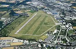
Wels Airfield Flugplatz Wels | |||||||||||||||||||
|---|---|---|---|---|---|---|---|---|---|---|---|---|---|---|---|---|---|---|---|
 | |||||||||||||||||||
| Summary | |||||||||||||||||||
| Airport type | Public | ||||||||||||||||||
| Operator | Weisse Möwe Wels | ||||||||||||||||||
| Serves | Wels, Austria | ||||||||||||||||||
| Elevation AMSL | 1,043 ft / 318 m | ||||||||||||||||||
| Coordinates | 48°10′59″N 014°02′27″E / 48.18306°N 14.04083°E | ||||||||||||||||||
| Website | http://www.wmw.at | ||||||||||||||||||
| Map | |||||||||||||||||||
 LOLW Location of Wels Airfield in Austria | |||||||||||||||||||
| Runways | |||||||||||||||||||
| |||||||||||||||||||
Wels Airfield (ICAO: LOLW) is an airfield serving Wels, a city in the Austrian state of Upper Austria. It is not used for commercial scheduled services but features business and general aviation as well as private and military training flights and medical transportation.[3]
See also
References
- ↑ "Airport information for LOLW". World Aero Data. Archived from the original on 5 March 2019.
{{cite web}}: CS1 maint: unfit URL (link) Data current as of October 2006. Source: DAFIF. - ↑ Airport information for LOLW at Great Circle Mapper. Source: DAFIF (effective October 2006).
- ↑ "Flugplatz Wels - Weiße Möwe Wels". www.wmw.at. Archived from the original on 7 April 2013.
External links
This article is issued from Wikipedia. The text is licensed under Creative Commons - Attribution - Sharealike. Additional terms may apply for the media files.