Welver | |
|---|---|
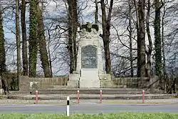 Monument to the Battle of Vellinghausen | |
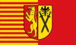 Flag  Coat of arms | |
Location of Welver within Soest district 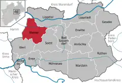 | |
 Welver  Welver | |
| Coordinates: 51°37′0″N 7°57′30″E / 51.61667°N 7.95833°E | |
| Country | Germany |
| State | North Rhine-Westphalia |
| Admin. region | Arnsberg |
| District | Soest |
| Subdivisions | 20 |
| Government | |
| • Mayor (2020–25) | Camillo Garzen[1] |
| Area | |
| • Total | 85.6 km2 (33.1 sq mi) |
| Elevation | 83 m (272 ft) |
| Population (2021-12-31)[2] | |
| • Total | 11,752 |
| • Density | 140/km2 (360/sq mi) |
| Time zone | UTC+01:00 (CET) |
| • Summer (DST) | UTC+02:00 (CEST) |
| Postal codes | 59514 |
| Dialling codes | 02384 |
| Vehicle registration | SO |
| Website | www.welver.de |
Welver is a municipality in the district of Soest, in North Rhine-Westphalia, Germany.
History
The town was once known as Villinghausen or Vellinghausen. The Seven Years' War Battle of Villinghausen was fought nearby.
Geography
Welver is situated approximately 12 km south-east of Hamm and 12 km north-west of Soest.
Neighbouring cities, towns, and municipalities
Division of the municipality
After the local government reforms of 1969, Welver consists of the following villages:
|
|
|
References
- ↑ Wahlergebnisse in NRW Kommunalwahlen 2020, Land Nordrhein-Westfalen, accessed 30 June 2021.
- ↑ "Bevölkerung der Gemeinden Nordrhein-Westfalens am 31. Dezember 2021" (in German). Landesbetrieb Information und Technik NRW. Retrieved 20 June 2022.
External links
- Official site (in German)
Towns and municipalities in Soest (district) | ||
|---|---|---|
Coat of Arms of Soest district | ||
This article is issued from Wikipedia. The text is licensed under Creative Commons - Attribution - Sharealike. Additional terms may apply for the media files.