| West Peak | |
|---|---|
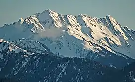
 West Peak in winter | |
| Highest point | |
| Elevation | 7,365 ft (2,245 m)[1] |
| Prominence | 1,965 ft (599 m)[1] |
| Coordinates | 47°43′24″N 123°20′56″W / 47.7232516°N 123.3490055°W[2] |
| Geography | |
 West Peak Location of West Peak in Washington  West Peak West Peak (the United States) | |
| Location | Olympic National Park Jefferson County, Washington, U.S. |
| Parent range | Olympic Mountains |
| Topo map | USGS Mount Steel |
| Climbing | |
| First ascent | 1930 by E. B. Hamilton |
| Easiest route | Scrambling class 3 via Flypaper Pass[3] |
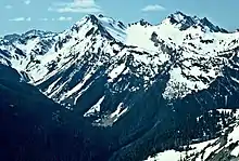
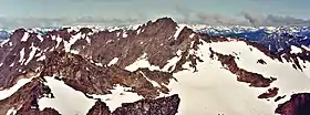
West Peak is a 7,365-foot-high (2,245 m) peak in the Olympic Mountains, in Jefferson County of Washington state.[2] Rising in the center of Olympic National Park, it is the highest peak on the Anderson Massif.[4] West Peak is the hydrographic apex of the Olympic Mountains, with precipitation runoff flowing outward to the Pacific Ocean via Quinault River, the Strait of Juan de Fuca via Elwha River, and Hood Canal via the Dosewallips River.[5] The Eel Glacier is situated in a cirque east of the summit, and an unnamed glacier resides in the south cirque. Its nearest higher peak is Mount Mystery, 7.73 miles (12.44 km) to the northeast.[1] The first ascent of the peak was made in 1930 by E. B. Hamilton.[3] Legend has it that the mountain's name is for Mr. West, a participant in the 1890 O'Neil Expedition, rather than for its apparent position on the Anderson Massif.[6] The West Branch of the Quinault River was named after him in 1890.[6]
Climate
West Peak is located in the marine west coast climate zone of western North America.[7]

Most weather fronts originate in the Pacific Ocean, and travel northeast toward the Olympic Mountains. As fronts approach, they are forced upward by the peaks of the Olympic Range, causing them to drop their moisture in the form of rain or snowfall (Orographic lift). As a result, the Olympics experience high precipitation, especially during the winter months in the form of snowfall.[7] During winter months, weather is usually cloudy, but, due to high pressure systems over the Pacific Ocean that intensify during summer months, there is often little or no cloud cover during the summer. The best months for climbing in terms of favorable weather are June through September.

Geology
The Olympic Mountains are composed of obducted clastic wedge material and oceanic crust, primarily Eocene sandstone, turbidite, and basaltic oceanic crust.[8] The mountains were sculpted during the Pleistocene era by erosion and glaciers advancing and retreating multiple times.
See also
References
- 1 2 3 "West Peak, Washington". Peakbagger.com.
- 1 2 "West Peak". Geographic Names Information System. United States Geological Survey, United States Department of the Interior. Retrieved 2019-10-07.
- 1 2 West Peak climbersguideolympics.com
- ↑ "Anderson Massif". Peakbagger.com.
- ↑ Olympic Mountain Rescue (2006). Olympic Mountains: A Climbing Guide. Mountaineers Books. p. 99. ISBN 978-0-89886-206-5. OCLC 62430882.
- 1 2 Parratt, Smitty (1984). Gods and Goblins: A Field Guide to Place Names of Olympic National Park (1st ed.).
- 1 2 McNulty, Tim (2009). Olympic National Park:A Natural History. Seattle, Washington: University of Washington Press.
- ↑ Alt, D.D.; Hyndman, D.W. (1984). Roadside Geology of Washington. pp. 249–259. ISBN 0-87842-160-2.
External links
- West Peak weather: Mountain Forecast
- West Peak aerial photo: PBase