Whitemarsh Island, Georgia | |
|---|---|
 | |
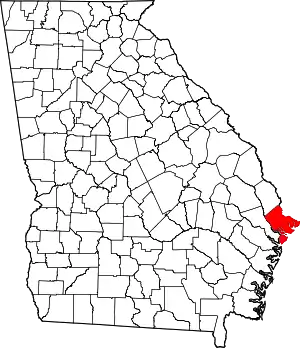
 Location in Chatham County and the state of Georgia | |
| Coordinates: 32°2′22″N 81°0′28″W / 32.03944°N 81.00778°W | |
| Country | United States |
| State | Georgia |
| County | Chatham |
| Area | |
| • Total | 6.65 sq mi (17.21 km2) |
| • Land | 5.82 sq mi (15.06 km2) |
| • Water | 0.83 sq mi (2.15 km2) |
| Elevation | 3 ft (0.9 m) |
| Population (2020) | |
| • Total | 6,983 |
| • Density | 1,200.86/sq mi (463.64/km2) |
| Time zone | UTC-5 (Eastern (EST)) |
| • Summer (DST) | UTC-4 (EDT) |
| FIPS code | 13-82636[3] |
| GNIS feature ID | 1867247[2] |
Whitemarsh Island (/ˈhwɪtmɑːrʃ/; WHIT-marsh) is an unincorporated community and census-designated place (CDP) in Chatham County, Georgia, United States. The population was 6,983 at the 2020 U.S census.[1] It is part of the Savannah metropolitan statistical area. The communities of Whitemarsh Island are a relatively affluent suburb of Savannah.
Geography
The Whitemarsh Island CDP is located at 32°2′22″N 81°0′28″W / 32.03944°N 81.00778°W (32.039482, -81.007850),[4] occupying the island of the same name. It is bordered to the north by Richardson Creek, to the east by Turner Creek, and to the south and west by the Wilmington River, all of which are tidal water bodies. U.S. Route 80 crosses the island, leading west into Savannah and east to Tybee Island on the Atlantic shore. The Islands Expressway runs northwest from Whitemarsh Island 6.5 miles (10.5 km) to downtown Savannah.
According to the United States Census Bureau, the Whitemarsh Island CDP has a total area of 6.6 square miles (17.2 km2), of which 5.6 square miles (14.6 km2) is land and 1.0 square mile (2.6 km2), or 15.10%, is water.[5]
Demographics
| Census | Pop. | Note | %± |
|---|---|---|---|
| 1990 | 2,554 | — | |
| 2000 | 5,824 | 128.0% | |
| 2010 | 6,792 | 16.6% | |
| 2020 | 6,983 | 2.8% | |
| U.S. Decennial Census[6] 1990[7] | |||
Whitemarsh Island was first listed as a CDP in the 1990 U.S. Census.[7]
| Race | Num. | Perc. |
|---|---|---|
| White (non-Hispanic) | 5,497 | 78.72% |
| Black or African American (non-Hispanic) | 379 | 5.43% |
| Native American | 12 | 0.17% |
| Asian | 455 | 6.52% |
| Pacific Islander | 2 | 0.03% |
| Other/Mixed | 378 | 5.41% |
| Hispanic or Latino | 260 | 3.72% |
As of the 2020 United States census, there were 6,983 people, 2,752 households, and 1,704 families residing in the CDP.
Education
It is in Savannah-Chatham County Public Schools.[9] Schools include:
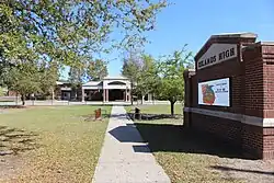
- Islands High School[10]
- Coastal Middle School[11]
- Marshpoint Elementary School[12]
Live Oak Public Libraries operates the Islands Library.[13]
 Coastal Middle School
 Marshpoint Elementary School
 Live Oak Public Libraries, Whitemarsh Island
References
- 1 2 "2020 U.S. Gazetteer Files". United States Census Bureau. Retrieved December 18, 2021.
- 1 2 U.S. Geological Survey Geographic Names Information System: Whitemarsh Island, Georgia
- ↑ "U.S. Census website". United States Census Bureau. Retrieved January 31, 2008.
- ↑ "US Gazetteer files: 2010, 2000, and 1990". United States Census Bureau. February 12, 2011. Retrieved April 23, 2011.
- ↑ "Geographic Identifiers: 2010 Demographic Profile Data (G001): Whitemarsh Island CDP, Georgia". U.S. Census Bureau, American Factfinder. Archived from the original on February 12, 2020. Retrieved July 24, 2014.
- ↑ "Decennial Census of Population and Housing by Decade". US Census Bureau.
- 1 2 "1990 Census of Population - General Population Characteristics - Georgia" (PDF). US Census Bureau. 1990.
- ↑ "Explore Census Data". data.census.gov. Retrieved December 14, 2021.
- ↑ "2020 CENSUS - SCHOOL DISTRICT REFERENCE MAP: Chatham County, GA" (PDF). U.S. Census Bureau. Retrieved March 19, 2023. - Text list
- ↑ "Home". Islands High School. Retrieved March 19, 2023.
170 Whitemarsh Island Road Savannah, GA 31410
- Despite the Savannah address, it is in the Whitemarsh Island CDP. - ↑ "Home". Coastal Middle School. Retrieved March 19, 2023.
4595 US Highway 80 East Savannah, GA 31410
- Despite the Savannah address, it is in the Whitemarsh Island CDP. - ↑ "Home". Marshpoint Elementary School. Retrieved March 19, 2023.
135 Whitemarsh Island Road Savannah, GA 31410
- Despite the Savannah address, it is in the Whitemarsh Island CDP. - ↑ "Islands". Live Oak Public Libraries. Retrieved March 19, 2023.
