Wingfield Township | |
|---|---|
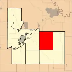 Location in Geary County | |
| Coordinates: 39°00′55″N 096°39′01″W / 39.01528°N 96.65028°W | |
| Country | United States |
| State | Kansas |
| County | Geary |
| Area | |
| • Total | 47.61 sq mi (123.32 km2) |
| • Land | 47.61 sq mi (123.32 km2) |
| • Water | 0 sq mi (0 km2) 0% |
| Elevation | 1,368 ft (417 m) |
| Population (2000) | |
| • Total | 139 |
| • Density | 2.9/sq mi (1.1/km2) |
| GNIS feature ID | 0476722 |
Wingfield Township is a township in Geary County, Kansas, USA. As of the 2000 census, its population was 139.
Geography
Wingfield Township covers an area of 47.61 square miles (123.3 km2) and contains no incorporated settlements. According to the USGS, it contains two cemeteries: Humboldt and Saint Joseph's.
The streams of East McDowell Creek, MacArthur Branch, Pressee Branch, Swede Creek, Thierer Branch and West McDowell Creek run through this township.
References
Further reading
External links
Municipalities and communities of Geary County, Kansas, United States | ||
|---|---|---|
| Cities | 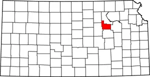 Map of Kansas highlighting Geary County | |
| Unincorporated communities | ||
| Ghost towns | ||
| Townships | ||
| Footnotes | †This community is designated a Census-Designated Place (CDP) by the United States Census Bureau. ‡This community also has portions in an adjacent county or counties. | |
This article is issued from Wikipedia. The text is licensed under Creative Commons - Attribution - Sharealike. Additional terms may apply for the media files.