Winston, New Mexico | |
|---|---|
Census-designated place | |
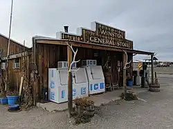 Winston General Store | |
 Winston, New Mexico | |
| Coordinates: 33°20′46″N 107°38′55″W / 33.34611°N 107.64861°W | |
| Country | United States |
| State | New Mexico |
| County | Sierra |
| Area | |
| • Total | 0.42 sq mi (1.09 km2) |
| • Land | 0.42 sq mi (1.09 km2) |
| • Water | 0.00 sq mi (0.00 km2) |
| Elevation | 6,175 ft (1,882 m) |
| Population | |
| • Total | 47 |
| • Density | 112.17/sq mi (43.31/km2) |
| Time zone | UTC-7 (Mountain (MST)) |
| • Summer (DST) | UTC-6 (MDT) |
| ZIP code | 87943 |
| Area code | 575 |
| GNIS feature ID | 2584240[2] |
Winston is a census-designated place in Sierra County, New Mexico, United States. Its population was 61 as of the 2010 census.[4] Winston has a post office with ZIP code 87943, which opened on August 15, 1881.[5][6] The community was named for Frank Winston, a pioneer miner.[7] New Mexico State Road 52 passes through the community.
Geography
According to the U.S. Census Bureau, the community has an area of 0.426 square miles (1.10 km2), all land.[4]
Demographics
| Census | Pop. | Note | %± |
|---|---|---|---|
| 2020 | 47 | — | |
| U.S. Decennial Census[8][3] | |||
Education
Truth or Consequences Municipal Schools is the school district for the entire county.[9] Truth or Consequences Middle School and Hot Springs High School, both in Truth or Consequences, are the district's secondary schools.
References
- ↑ "ArcGIS REST Services Directory". United States Census Bureau. Retrieved October 12, 2022.
- 1 2 U.S. Geological Survey Geographic Names Information System: Winston, New Mexico
- 1 2 "Census Population API". United States Census Bureau. Retrieved October 12, 2022.
- 1 2 "2010 Census Gazetteer Files - Places: New Mexico". U.S. Census Bureau. Retrieved August 21, 2014.
- ↑ "Postmaster Finder - Post Offices by ZIP Code". United States Postal Service. Retrieved August 21, 2014.
- ↑ United States Postal Service. "USPS - Look Up a ZIP Code". Retrieved August 21, 2014.
- ↑ Harris, Linda G. (2003). Ghost Towns Alive: Trips to New Mexico's Past. UNM Press. p. 144. ISBN 978-0-8263-2908-0.
- ↑ "Census of Population and Housing". Census.gov. Retrieved June 4, 2016.
- ↑ "2020 CENSUS - SCHOOL DISTRICT REFERENCE MAP: Sierra County, NM" (PDF). U.S. Census Bureau. Retrieved July 12, 2022. - Text list
External links
Municipalities and communities of Sierra County, New Mexico, United States | ||
|---|---|---|
| Cities |  Map of New Mexico highlighting Sierra County | |
| Villages | ||
| CDPs | ||
| Other communities | ||
| Ghost towns | ||
This article is issued from Wikipedia. The text is licensed under Creative Commons - Attribution - Sharealike. Additional terms may apply for the media files.