Wolcott, Colorado | |
|---|---|
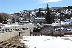
 Bridge over the Eagle River in Wolcott. | |
 Location of the Wolcott CDP in Eagle County, Colorado. | |
 Wolcott Location of the Wolcott CDP in the United States. | |
| Coordinates: 39°42′12″N 106°40′48″W / 39.70333°N 106.68000°W[1] | |
| Country | |
| State | |
| County | Eagle County |
| Government | |
| • Type | unincorporated town |
| Area | |
| • Total | 0.385 sq mi (0.996 km2) |
| • Land | 0.369 sq mi (0.956 km2) |
| • Water | 0.015 sq mi (0.040 km2) |
| Elevation | 7,044 ft (2,147 m) |
| Population | |
| • Total | 20 |
| • Density | 52/sq mi (20/km2) |
| Time zone | UTC-7 (MST) |
| • Summer (DST) | UTC-6 (MDT) |
| ZIP Code[4] | 81655 |
| Area code | 970 |
| GNIS feature | 2583318[2] |
Wolcott is an unincorporated town, a post office, and a census-designated place (CDP) located in and governed by Eagle County, Colorado, United States. The CDP is a part of the Edwards, CO Micropolitan Statistical Area. The Wolcott post office has the ZIP Code 81655 (post office boxes).[4] At the United States Census 2020, the population of the Wolcott CDP was 20.[3]
History
The Wolcott Post Office has been in operation since 1889.[5] The community was named after Edward O. Wolcott, a United States Senator from Colorado.[6]
Geography
Wolcott is located in central Eagle County in the valley of the Eagle River, a west-flowing tributary of the Colorado River. U.S. Route 6 passes through the community, following the river, while Interstate 70 forms the southern edge of the CDP, with access from Exit 157. I-70 and US-6 each lead 7 miles (11 km) east to Edwards and west 10 miles (16 km) to Eagle, the county seat. Colorado State Highway 131 intersects I-70 at Exit 157, passes through the center of Wolcott, and leads north 72 miles (116 km) to Steamboat Springs.
The Wolcott CDP has an area of 246 acres (0.996 km2), including 9.9 acres (0.040 km2) of water.[1]
Demographics
The United States Census Bureau initially defined the Wolcott CDP for the United States Census 2010.
| Year | Pop. | ±% |
|---|---|---|
| 2010 | 15 | — |
| 2020 | 20 | +33.3% |
| Source: United States Census Bureau | ||
See also
References
- 1 2 3 "State of Colorado Census Designated Places - BAS20 - Data as of January 1, 2020". United States Census Bureau. Retrieved December 21, 2020.
- 1 2 3 U.S. Geological Survey Geographic Names Information System: Wolcott, Colorado
- 1 2 United States Census Bureau. "Wolcott CDP, Colorado". Retrieved April 17, 2023.
- 1 2 "Look Up a ZIP Code". United States Postal Service. Retrieved December 21, 2020.
- ↑ "Post offices". Jim Forte Postal History. Retrieved July 11, 2016.
- ↑ Dawson, John Frank. Place names in Colorado: why 700 communities were so named, 150 of Spanish or Indian origin. Denver, CO: The J. Frank Dawson Publishing Co. p. 52.
