| Woodend North Victoria | |||||||||||||||
|---|---|---|---|---|---|---|---|---|---|---|---|---|---|---|---|
 The former Woodend North State School | |||||||||||||||
 Woodend North | |||||||||||||||
| Coordinates | 37°19′S 144°32′E / 37.317°S 144.533°E | ||||||||||||||
| Population | 313 (2006 census)[1] | ||||||||||||||
| Postcode(s) | 3442 | ||||||||||||||
| Elevation | 550 m (1,804 ft) | ||||||||||||||
| Location |
| ||||||||||||||
| LGA(s) | Shire of Macedon Ranges | ||||||||||||||
| State electorate(s) | Macedon | ||||||||||||||
| Federal division(s) | McEwen | ||||||||||||||
| |||||||||||||||
Woodend North (traditionally North Woodend) is a locality 4 km north of Woodend, Victoria in the Shire of Macedon Ranges in central Victoria, Australia. Formerly a distinct locality, Woodend North has effectively become the northern extension of the township of Woodend. The locality is now a mainly residential and agricultural area, with some light secondary industrial sites. At the 2006 census, Woodend North had a population of 313.[1]

History
Woodend North was originally known as Springfield, supposedly in reference to natural springs in the area.[2] The name seems to have been changed due to postal confusion with another Springfield office near Romsey.
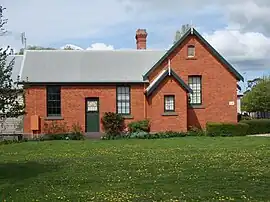
The settlement formerly consisted of the Post Office, State School, a general store, a blacksmith, and Patterson's (flour) Mill,[2] all of which are now closed. Further, Woodend North featured three licensed hotels, the Springfield, Highland Chief and Dalhousie.[2] The Post Office opened as Springfield on 11 November 1862, was renamed Woodend North on 8 September 1884, and closed on 31 January 1958.[3] The former Woodend North State School remains standing as a privately owned residence.
References
- 1 2 Australian Bureau of Statistics (25 October 2007). "Woodend North (State Suburb)". 2006 Census QuickStats. Retrieved 31 October 2010.
- 1 2 3 Barned, Betty Jean (1985). Woodend on the Five Mile Creek. Woodend, Victoria: B. J. Barned. pp. 42–44. ISBN 1-86252-255-3.
- ↑ Premier Postal History, Post Office List, retrieved 11 May 2010