Wormeldange
Wuermer, Wormer | |
|---|---|
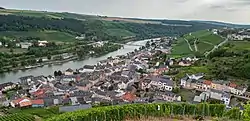 Wormeldange seen from the nearby chapel Koeppchen | |
 Coat of arms | |
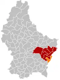 Map of Luxembourg with Wormeldange highlighted in orange, and the canton in dark red | |
| Coordinates: 49°36′40″N 6°24′20″E / 49.6111°N 6.4056°E | |
| Country | |
| Canton | Grevenmacher |
| Government | |
| • Mayor | Max Hengel (CSV) |
| Area | |
| • Total | 17.25 km2 (6.66 sq mi) |
| • Rank | 68th of 102 |
| Highest elevation | 355 m (1,165 ft) |
| • Rank | 82nd of 102 |
| Lowest elevation | 137 m (449 ft) |
| • Rank | 3rd of 102 |
| Population (2023) | |
| • Total | 23,171 |
| • Rank | 52nd of 102 |
| • Density | 1,300/km2 (3,500/sq mi) |
| • Rank | 46th of 102 |
| Time zone | UTC+1 (CET) |
| • Summer (DST) | UTC+2 (CEST) |
| LAU 2 | LU0001108 |
| Website | wormeldange.lu |
Wormeldange (Luxembourgish: Wuermer [ˈvuːɐ̯mɐ] or (locally) Wormer; German: Wormeldingen) is a commune and small town in eastern Luxembourg. It is part of the canton of Grevenmacher.
As of 2005, the town of Wormeldange, which lies in the south of the commune, has a population of 742. Other towns within the commune include Ahn, Ehnen, Machtum, and Wormeldange-Haut.
Population
References
- ↑ "WORMELDANGE - Syvicol". www.syvicol.lu. Retrieved 3 April 2019.
- ↑ "Population par canton et commune". statistiques.public.lu. Retrieved 11 January 2022.
External links
 Media related to Wormeldange at Wikimedia Commons
Places adjacent to Wormeldange | ||||||||||||||||
|---|---|---|---|---|---|---|---|---|---|---|---|---|---|---|---|---|
| ||||||||||||||||
 | ||
This article is issued from Wikipedia. The text is licensed under Creative Commons - Attribution - Sharealike. Additional terms may apply for the media files.