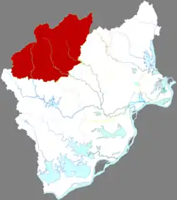
Yuexi
岳西县 | |
|---|---|
 Yuexi in Anqing | |
.png.webp) Anqing in Anhui | |
| Coordinates: 30°50′58″N 116°21′36″E / 30.8494°N 116.3599°E | |
| Country | People's Republic of China |
| Province | Anhui |
| Prefecture-level city | Anqing |
| Area | |
| • Total | 2,398 km2 (926 sq mi) |
| Population (2018) | |
| • Total | 412,418 |
| • Density | 170/km2 (450/sq mi) |
| Time zone | UTC+8 (China Standard) |
| Postal code | 246600 |
Yuexi County (simplified Chinese: 岳西县; traditional Chinese: 岳西縣; pinyin: Yuèxī Xiàn), is a county in the southwest of Anhui Province, People's Republic of China, bordering Hubei Province to the west. It is under the jurisdiction of the prefecture-level city of Anqing. It has a population of 400,000 and an area of 2,398 km2 (926 sq mi). The government of Yuexi County is located in Tiantang Town.
Administrative divisions
Yuexi County has jurisdiction over thirteen towns and eleven townships.[1]
Towns:
- Tiantang (天堂镇), Dianqian (店前镇), Laipang (来榜镇), Changpu (菖蒲镇), Toutuo (头陀镇), Baimao (白帽镇), Wenquan (温泉镇), Xiangchang (响肠镇), Hetu (河图镇), Wuhe (五河镇), Zhubu (主簿镇), Yexi (冶溪镇), Huangwei (黄尾镇)
Townships:
- Lianyun Township (莲云乡), Qingtian Township (青天乡), Baojia Township (包家乡), Gufang Township (古坊乡), Tiantou Township (田头乡), Zhongguan Township (中关乡), Shiguan Township (石关乡), Yaohe Township (姚河乡), Heping Township, Yuexi County (和平乡), Weiling Township (巍岭乡), Maojianshan Township (毛尖山乡)
Climate
| Climate data for Yuexi (1991–2020 normals, extremes 1981–2010) | |||||||||||||
|---|---|---|---|---|---|---|---|---|---|---|---|---|---|
| Month | Jan | Feb | Mar | Apr | May | Jun | Jul | Aug | Sep | Oct | Nov | Dec | Year |
| Record high °C (°F) | 21.6 (70.9) |
24.3 (75.7) |
30.0 (86.0) |
31.0 (87.8) |
34.9 (94.8) |
36.3 (97.3) |
38.0 (100.4) |
38.3 (100.9) |
36.3 (97.3) |
32.8 (91.0) |
27.9 (82.2) |
23.0 (73.4) |
38.3 (100.9) |
| Mean daily maximum °C (°F) | 8.2 (46.8) |
10.7 (51.3) |
15.3 (59.5) |
21.5 (70.7) |
25.7 (78.3) |
28.2 (82.8) |
31.0 (87.8) |
30.9 (87.6) |
27.4 (81.3) |
22.5 (72.5) |
16.8 (62.2) |
10.8 (51.4) |
20.8 (69.4) |
| Daily mean °C (°F) | 2.5 (36.5) |
4.9 (40.8) |
9.1 (48.4) |
15.1 (59.2) |
19.9 (67.8) |
23.1 (73.6) |
26.0 (78.8) |
25.2 (77.4) |
21.4 (70.5) |
15.9 (60.6) |
10.0 (50.0) |
4.4 (39.9) |
14.8 (58.6) |
| Mean daily minimum °C (°F) | −1.3 (29.7) |
0.9 (33.6) |
4.6 (40.3) |
10.3 (50.5) |
15.3 (59.5) |
19.3 (66.7) |
22.4 (72.3) |
21.7 (71.1) |
17.3 (63.1) |
11.3 (52.3) |
5.3 (41.5) |
0.1 (32.2) |
10.6 (51.1) |
| Record low °C (°F) | −11.2 (11.8) |
−8.9 (16.0) |
−6.9 (19.6) |
−0.7 (30.7) |
4.6 (40.3) |
10.4 (50.7) |
15.6 (60.1) |
14.9 (58.8) |
7.1 (44.8) |
−0.6 (30.9) |
−6.7 (19.9) |
−12.8 (9.0) |
−12.8 (9.0) |
| Average precipitation mm (inches) | 53.3 (2.10) |
72.2 (2.84) |
106.5 (4.19) |
144.7 (5.70) |
169.5 (6.67) |
266.9 (10.51) |
260.4 (10.25) |
194.5 (7.66) |
108.5 (4.27) |
61.6 (2.43) |
51.9 (2.04) |
35.8 (1.41) |
1,525.8 (60.07) |
| Average precipitation days (≥ 0.1 mm) | 11.1 | 11.2 | 13.7 | 13.0 | 13.9 | 14.8 | 15.1 | 16.3 | 9.9 | 9.6 | 9.0 | 8.0 | 145.6 |
| Average snowy days | 6.6 | 3.6 | 1.8 | 0.1 | 0 | 0 | 0 | 0 | 0 | 0 | 0.6 | 2.1 | 14.8 |
| Average relative humidity (%) | 74 | 75 | 74 | 74 | 76 | 82 | 83 | 84 | 79 | 76 | 75 | 72 | 77 |
| Mean monthly sunshine hours | 124.7 | 117.2 | 143.3 | 170.7 | 180.9 | 159.6 | 195.5 | 196.8 | 172.0 | 164.8 | 153.3 | 144.5 | 1,923.3 |
| Percent possible sunshine | 39 | 37 | 38 | 44 | 42 | 38 | 46 | 48 | 47 | 47 | 49 | 46 | 43 |
| Source: China Meteorological Administration[2][3] | |||||||||||||
Transport
References
- ↑ 蚌埠市-行政区划王 (in Chinese). XZQH. Retrieved 2012-05-24.
- ↑ 中国气象数据网 – WeatherBk Data (in Simplified Chinese). China Meteorological Administration. Retrieved 27 June 2023.
- ↑ 中国气象数据网 (in Simplified Chinese). China Meteorological Administration. Retrieved 27 June 2023.
This article is issued from Wikipedia. The text is licensed under Creative Commons - Attribution - Sharealike. Additional terms may apply for the media files.