Zamarra | |
|---|---|
 Flag  Seal | |
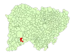 Location in Salamanca | |
| Coordinates: 40°31′6″N 6°27′14″W / 40.51833°N 6.45389°W | |
| Country | Spain |
| Autonomous community | Castile and León |
| Province | Salamanca |
| Comarca | Comarca de Ciudad Rodrigo |
| Subcomarca | Los Agadones |
| Government | |
| • Mayor | Ángel Morán Jato (People's Party) |
| Area | |
| • Total | 48 km2 (19 sq mi) |
| Elevation | 778 m (2,552 ft) |
| Population (2018)[2] | |
| • Total | 98 |
| • Density | 2.0/km2 (5.3/sq mi) |
| Time zone | UTC+1 (CET) |
| • Summer (DST) | UTC+2 (CEST) |
| Postal code | 37591 |
Zamarra is a municipality in the province of Salamanca, western Spain, part of the autonomous community of Castile-Leon. It is located 100 kilometres from the city of Salamanca and as of 2016 has a population of 105 people. The municipality covers an area of 48 km².
The village lies 778 metres above sea level and the postal code is 37591.[1]
References
- 1 2 3 "Municipio:Zamarra". www.lasalina.es. Retrieved 2017-11-03.
- ↑ Municipal Register of Spain 2018. National Statistics Institute.
This article is issued from Wikipedia. The text is licensed under Creative Commons - Attribution - Sharealike. Additional terms may apply for the media files.