Zvončín | |
|---|---|
Municipality | |
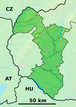 Zvončín Location of Zvončín in the Trnava Region  Zvončín Zvončín (Slovakia) | |
| Coordinates: 48°24′0″N 17°30′15″E / 48.40000°N 17.50417°E | |
| Country | Slovakia |
| Region | Trnava |
| District | Trnava |
| Area | |
| • Total | 8.24[1] km2 (3.18[1] sq mi) |
| Elevation | 156[2] m (512[2] ft) |
| Population (2021) | |
| • Total | 974[3] |
| Time zone | UTC+1 (CET) |
| • Summer (DST) | UTC+2 (CET) |
| Postal code | 919 01[2] |
| Phone prefix | +421 33[2] |
| Car plate | TT |
| Website | www.zvoncin.eu |
Zvončín (Hungarian: Harangfalva) is a village and municipality of Trnava District in the Trnava region of Slovakia.
References
- 1 2 "Hustota obyvateľstva - obce [om7014rr_ukaz: Rozloha (Štvorcový meter)]". www.statistics.sk (in Slovak). Statistical Office of the Slovak Republic. 2022-03-31. Retrieved 2022-03-31.
- 1 2 3 4 "Základná charakteristika". www.statistics.sk (in Slovak). Statistical Office of the Slovak Republic. 2015-04-17. Retrieved 2022-03-31.
- ↑ "Počet obyvateľov podľa pohlavia - obce (ročne)". www.statistics.sk (in Slovak). Statistical Office of the Slovak Republic. 2022-03-31. Retrieved 2022-03-31.
External links
- Official website
- http://en.e-obce.sk/obec/zvoncin/zvoncin.html
- https://web.archive.org/web/20070427022352/http://www.statistics.sk/mosmis/eng/run.html
This article is issued from Wikipedia. The text is licensed under Creative Commons - Attribution - Sharealike. Additional terms may apply for the media files.