北达科他州县级行政区列表
| 北达科他州行政区划 | |
|---|---|
| 位置 | 北达科他州 |
| 數量 | 53 |
| 人口 | 727(斯洛普县)–149,778(卡斯县) |
| 面積 | 632平方英里(1,640平方)(埃迪县)–2,742平方英里(7,100平方)(麦肯齐县) |
| 本级政府 | 县政府 |
| 下級 | 城、镇、乡、非法人社区、印第安人保留地、普查规定居民点 |
每个条目都提供了美国政府用来唯一识别州和县的联邦资料处理标准(FIPS)代码。[1]北达科他州的代码是38,当与任何县代码结合使用时,代码为38XXX。每个县的FIPS代码链接到该县的人口普查数据。[2]
县份列表
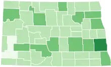
北达科州的县份,颜色深度根据人口
| 县 |
FIPS代码 [2] |
縣治 [3] |
建立 [3] |
名稱來源 [4] |
人口 [3][5] |
面积 [3][5] |
地图 |
|---|---|---|---|---|---|---|---|
| 亞當斯縣 | 001 | 黑廷格 | 1885 | 约翰·昆西·亚当斯(John Quincy Adams)是一位铁路代理人,也是前总统的堂弟,他在让密尔沃基铁路穿过北达科他州的过程中发挥了作用。 | 2,343 | 988平方英里 (2,559平方公里) |  |
| 巴恩斯縣 | 003 | 谷市 | 1875 | Dakota Territory judge Alanson H. Barnes | 11,066 | 1,492平方英里 (3,864平方公里) |  |
| 本森縣 | 005 | 明尼沃肯 | 1883 | Dakota territorial legislator Bertil W. Benson | 6,660 | 1,389平方英里 (3,597平方公里) | [[Image:Map of North Dakota highlighting {{{English}}} County.svg|150px|alt=標示出本森縣位置的地圖|標示出本森縣位置的地圖]] |
| 比靈斯縣 | 007 | 梅多拉 | 1879 | Frederick H. Billings (1823–1890), who was president of the Northern Pacific Railroad | 783 | 1,152平方英里 (2,984平方公里) | [[Image:Map of North Dakota highlighting {{{English}}} County.svg|150px|alt=標示出比靈斯縣位置的地圖|標示出比靈斯縣位置的地圖]] |
| 博蒂諾縣 | 009 | 波特诺 | 1873 | Named for frontiersman Pierre Bottineau | 6,429 | 1,669平方英里 (4,323平方公里) | [[Image:Map of North Dakota highlighting {{{English}}} County.svg|150px|alt=標示出博蒂諾縣位置的地圖|標示出博蒂諾縣位置的地圖]] |
| 鮑曼縣 | 011 | 鲍曼 | 1883 | Dakota territorial legislator Edward M. Bowman | 3,151 | 1,162平方英里 (3,010平方公里) | [[Image:Map of North Dakota highlighting {{{English}}} County.svg|150px|alt=標示出鮑曼縣位置的地圖|標示出鮑曼縣位置的地圖]] |
| 伯克縣 | 013 | 鲍贝尔斯 | 1910 | John Burke, tenth Governor of North Dakota | 1,968 | 1,104平方英里 (2,859平方公里) | [[Image:Map of North Dakota highlighting {{{English}}} County.svg|150px|alt=標示出伯克縣位置的地圖|標示出伯克縣位置的地圖]] |
| 伯利縣 | 015 | 俾斯麦 | 1873 | Walter A. Burleigh (1820–1896), territorial delegate to Congress | 81,308 | 1,633平方英里 (4,229平方公里) | [[Image:Map of North Dakota highlighting {{{English}}} County.svg|150px|alt=標示出伯利縣位置的地圖|標示出伯利縣位置的地圖]] |
| 卡斯縣 | 017 | 法戈 | 1873 | George Washington Cass (1810–1888), who was the president of the Northern Pacific Railroad | 149,778 | 1,766平方英里 (4,574平方公里) | [[Image:Map of North Dakota highlighting {{{English}}} County.svg|150px|alt=標示出卡斯縣位置的地圖|標示出卡斯縣位置的地圖]] |
| 卡弗利爾縣 | 019 | 兰登 | 1873 | Charles Cavalier, French fur trapper and one of the area's original settlers | 3,993 | 1,489平方英里 (3,856平方公里) | [[Image:Map of North Dakota highlighting {{{English}}} County.svg|150px|alt=標示出卡弗利爾縣位置的地圖|標示出卡弗利爾縣位置的地圖]] |
| 迪基縣 | 021 | 埃伦代尔 | 1881 | Dakota territorial legislator George H. Dickey | 5,289 | 1,131平方英里 (2,929平方公里) | [[Image:Map of North Dakota highlighting {{{English}}} County.svg|150px|alt=標示出迪基縣位置的地圖|標示出迪基縣位置的地圖]] |
| 迪瓦德縣 | 023 | Crosby | 1910 | Named because it was created upon the division of Williams County | 2,071 | 1,259平方英里 (3,261平方公里) | [[Image:Map of North Dakota highlighting {{{English}}} County.svg|150px|alt=標示出迪瓦德縣位置的地圖|標示出迪瓦德縣位置的地圖]] |
| 鄧恩縣 | 025 | Manning | 1883 | John P. Dunn, an early civic leader of Bismarck, who opened the first drugstore in North Dakota | 3,536 | 2,010平方英里 (5,206平方公里) | [[Image:Map of North Dakota highlighting {{{English}}} County.svg|150px|alt=標示出鄧恩縣位置的地圖|標示出鄧恩縣位置的地圖]] |
| 埃迪縣 | 027 | New Rockford | 1885 | Ezra B. Eddy, a Fargo banker and one of the territory's wealthiest citizens | 2,385 | 632平方英里 (1,637平方公里) | [[Image:Map of North Dakota highlighting {{{English}}} County.svg|150px|alt=標示出埃迪縣位置的地圖|標示出埃迪縣位置的地圖]] |
| 埃蒙斯縣 | 029 | Linton | 1879 | James Emmons, an early entrepreneur and businessman who operated the first steamboat across the Missouri River in Bismarck | 3,550 | 1,510平方英里 (3,911平方公里) | [[Image:Map of North Dakota highlighting {{{English}}} County.svg|150px|alt=標示出埃蒙斯縣位置的地圖|標示出埃蒙斯縣位置的地圖]] |
| 福斯特縣 | 031 | Carrington | 1873 | Either James S. Foster and George I. Foster, brother, and prominent farmers during the territorial days | 3,343 | 635平方英里 (1,645平方公里) | [[Image:Map of North Dakota highlighting {{{English}}} County.svg|150px|alt=標示出福斯特縣位置的地圖|標示出福斯特縣位置的地圖]] |
| 戈爾登瓦利縣 | 033 | Beach | 1912 | Named for either promotional reasons or for the Golden Valley Land and Cattle Company | 1,680 | 1,002平方英里 (2,595平方公里) | [[Image:Map of North Dakota highlighting {{{English}}} County.svg|150px|alt=標示出戈爾登瓦利縣位置的地圖|標示出戈爾登瓦利縣位置的地圖]] |
| 大福克斯縣 | 035 | Grand Forks | 1873 | Named for Grand Forks, North Dakota, which in turn was named for its location at the intersection of the Red Lake River and the Red River of the North | 66,861 | 1,438平方英里 (3,724平方公里) | [[Image:Map of North Dakota highlighting {{{English}}} County.svg|150px|alt=標示出大福克斯縣位置的地圖|標示出大福克斯縣位置的地圖]] |
| 格蘭特縣 | 037 | Carson | 1916 | Ulysses S. Grant (1822–1885), eighteenth U.S. President | 2,394 | 1,660平方英里 (4,299平方公里) | [[Image:Map of North Dakota highlighting {{{English}}} County.svg|150px|alt=標示出格蘭特縣位置的地圖|標示出格蘭特縣位置的地圖]] |
| 格里格斯縣 | 039 | Cooperstown | 1881 | Alexander Griggs, a steamboat captain and founder of Grand Forks, North Dakota | 2,420 | 708平方英里 (1,834平方公里) | [[Image:Map of North Dakota highlighting {{{English}}} County.svg|150px|alt=標示出格里格斯縣位置的地圖|標示出格里格斯縣位置的地圖]] |
| 赫廷傑縣 | 041 | Mott | 1883 | Mathias K. Hettinger, the father-in-law of Erastus A. Williams, the North Dakota Speaker of the House during that session | 2,477 | 1,132平方英里 (2,932平方公里) | [[Image:Map of North Dakota highlighting {{{English}}} County.svg|150px|alt=標示出赫廷傑縣位置的地圖|標示出赫廷傑縣位置的地圖]] |
| 基德縣 | 043 | Steele | 1873 | Jefferson Parrish Kidder, territorial delegate to the 44th Congress and 45th Congresses | 2,435 | 1,352平方英里 (3,502平方公里) | [[Image:Map of North Dakota highlighting {{{English}}} County.svg|150px|alt=標示出基德縣位置的地圖|標示出基德縣位置的地圖]] |
| 拉穆爾縣 | 045 | LaMoure | 1873 | Dakota territorial legislator and North Dakota state legislator Judson LaMoure | 4,139 | 1,147平方英里 (2,971平方公里) | [[Image:Map of North Dakota highlighting {{{English}}} County.svg|150px|alt=標示出拉穆爾縣位置的地圖|標示出拉穆爾縣位置的地圖]] |
| 洛根縣 | 047 | Napoleon | 1873 | Illinois U.S. Senator John A. Logan (1826–1886) | 1,990 | 993平方英里 (2,572平方公里) | [[Image:Map of North Dakota highlighting {{{English}}} County.svg|150px|alt=標示出洛根縣位置的地圖|標示出洛根縣位置的地圖]] |
| 麥克亨利縣 | 049 | Towner | 1873 | James McHenry, one of the area's original settlers | 5,395 | 1,874平方英里 (4,854平方公里) | [[Image:Map of North Dakota highlighting {{{English}}} County.svg|150px|alt=標示出麥克亨利縣位置的地圖|標示出麥克亨利縣位置的地圖]] |
| 麥金托什縣 | 051 | Ashley | 1883 | Edward H. McIntosh, a member of the Territorial Legislature | 2,809 | 975平方英里 (2,525平方公里) | [[Image:Map of North Dakota highlighting {{{English}}} County.svg|150px|alt=標示出麥金托什縣位置的地圖|標示出麥金托什縣位置的地圖]] |
| 麥肯齊縣 | 053 | Watford City | 1905 | Alexander McKenzie, party boss known in the state as "the senator-maker" | 6,360 | 2,742平方英里 (7,102平方公里) | [[Image:Map of North Dakota highlighting {{{English}}} County.svg|150px|alt=標示出麥肯齊縣位置的地圖|標示出麥肯齊縣位置的地圖]] |
| 麥克萊恩縣 | 055 | Washburn | 1883 | John A. McLean, first mayor of Bismarck, North Dakota | 8,962 | 2,110平方英里 (5,465平方公里) | [[Image:Map of North Dakota highlighting {{{English}}} County.svg|150px|alt=標示出麥克萊恩縣位置的地圖|標示出麥克萊恩縣位置的地圖]] |
| 默瑟縣 | 057 | Stanton | 1875 | William Henry Harrison Mercer, an early settler | 8,424 | 1,045平方英里 (2,707平方公里) | [[Image:Map of North Dakota highlighting {{{English}}} County.svg|150px|alt=標示出默瑟縣位置的地圖|標示出默瑟縣位置的地圖]] |
| 莫頓縣 | 059 | Mandan | 1873 | Governor of Indiana Oliver Hazard Perry Throck Morton | 27,471 | 1,926平方英里 (4,988平方公里) | [[Image:Map of North Dakota highlighting {{{English}}} County.svg|150px|alt=標示出莫頓縣位置的地圖|標示出莫頓縣位置的地圖]] |
| 芒特雷爾縣 | 061 | Stanley | 1873 | Joseph Mountraille, Metis voyageur and early explorer | 7,673 | 1,824平方英里 (4,724平方公里) | [[Image:Map of North Dakota highlighting {{{English}}} County.svg|150px|alt=標示出芒特雷爾縣位置的地圖|標示出芒特雷爾縣位置的地圖]] |
| 納爾遜縣 | 063 | Lakota | 1883 | Dakota territorial legislator Nelson E. Nelson | 3,126 | 982平方英里 (2,543平方公里) | [[Image:Map of North Dakota highlighting {{{English}}} County.svg|150px|alt=標示出納爾遜縣位置的地圖|標示出納爾遜縣位置的地圖]] |
| 奧利弗縣 | 065 | Center | 1885 | Dakota territorial legislator Harry S. Oliver | 1,846 | 724平方英里 (1,875平方公里) | [[Image:Map of North Dakota highlighting {{{English}}} County.svg|150px|alt=標示出奧利弗縣位置的地圖|標示出奧利弗縣位置的地圖]] |
| 彭比納縣 | 067 | Cavalier | 1867 | Named for the high-bush cranberries which grew wild in the area. Pembina may be from an Ojibwa phrase, anepeminan sipi, referring to the berries, as they grew in abundance around the Redberry River; it may also be from an Ojibwa word meaning meeting place. The name originally applied to the old Pembina Territory | 7,413 | 1,119平方英里 (2,898平方公里) | [[Image:Map of North Dakota highlighting {{{English}}} County.svg|150px|alt=標示出彭比納縣位置的地圖|標示出彭比納縣位置的地圖]] |
| 皮爾斯縣 | 069 | Rugby | 1887 | Gilbert Ashville Pierce, a Governor of Dakota Territory and later a U.S. Senator from North Dakota | 4,357 | 1,018平方英里 (2,637平方公里) | [[Image:Map of North Dakota highlighting {{{English}}} County.svg|150px|alt=標示出皮爾斯縣位置的地圖|標示出皮爾斯縣位置的地圖]] |
| 拉姆西縣 | 071 | Devils Lake | 1873 | Minnesota U.S. Senator Alexander Ramsey | 11,451 | 1,186平方英里 (3,072平方公里) | [[Image:Map of North Dakota highlighting {{{English}}} County.svg|150px|alt=標示出拉姆西縣位置的地圖|標示出拉姆西縣位置的地圖]] |
| 蘭森姆縣 | 073 | Lisbon | 1873 | Named for locally situated Fort Ransom | 5,457 | 863平方英里 (2,235平方公里) | [[Image:Map of North Dakota highlighting {{{English}}} County.svg|150px|alt=標示出蘭森姆縣位置的地圖|標示出蘭森姆縣位置的地圖]] |
| 倫維爾縣 | 075 | Mohall | 1873 | Joseph Renville, missionary and interpreter for Dakota Native Americans | 2,470 | 875平方英里 (2,266平方公里) | [[Image:Map of North Dakota highlighting {{{English}}} County.svg|150px|alt=標示出倫維爾縣位置的地圖|標示出倫維爾縣位置的地圖]] |
| 里奇蘭縣 | 077 | Wahpeton | 1873 | Morgan T. Rich, early settler | 16,321 | 1,437平方英里 (3,722平方公里) | [[Image:Map of North Dakota highlighting {{{English}}} County.svg|150px|alt=標示出里奇蘭縣位置的地圖|標示出里奇蘭縣位置的地圖]] |
| 羅利特縣 | 079 | Rolla | 1873 | Joseph Rolette, Jr. (1820–1871), a prominent fur trapper and local political organizer | 13,937 | 902平方英里 (2,336平方公里) | [[Image:Map of North Dakota highlighting {{{English}}} County.svg|150px|alt=標示出羅利特縣位置的地圖|標示出羅利特縣位置的地圖]] |
| 薩金特縣 | 081 | Forman | 1883 | Homer E. Sargent, a general manager of the Northern Pacific Railroad | 3,829 | 859平方英里 (2,225平方公里) | [[Image:Map of North Dakota highlighting {{{English}}} County.svg|150px|alt=標示出薩金特縣位置的地圖|標示出薩金特縣位置的地圖]] |
| 謝里登縣 | 083 | McClusky | 1873 | American Civil War officer Philip Henry Sheridan (1831–1888) | 1,321 | 972平方英里 (2,517平方公里) | [[Image:Map of North Dakota highlighting {{{English}}} County.svg|150px|alt=標示出謝里登縣位置的地圖|標示出謝里登縣位置的地圖]] |
| 蘇縣 | 085 | Fort Yates | 1915 | The Native American Sioux people | 4,153 | 1,094平方英里 (2,833平方公里) | [[Image:Map of North Dakota highlighting {{{English}}} County.svg|150px|alt=標示出蘇縣位置的地圖|標示出蘇縣位置的地圖]] |
| 斯洛普縣 | 087 | Amidon | 1915 | Topographical feature within the county known as the Missouri Slope | 727 | 1,218平方英里 (3,155平方公里) | [[Image:Map of North Dakota highlighting {{{English}}} County.svg|150px|alt=標示出斯洛普縣位置的地圖|標示出斯洛普縣位置的地圖]] |
| 斯塔克縣 | 089 | Dickinson | 1879 | George Stark, a vice president of the Northern Pacific Railroad | 24,199 | 1,338平方英里 (3,465平方公里) | [[Image:Map of North Dakota highlighting {{{English}}} County.svg|150px|alt=標示出斯塔克縣位置的地圖|標示出斯塔克縣位置的地圖]] |
| 斯蒂爾縣 | 091 | Finley | 1883 | Edward H. Steele, secretary-treasurer of the Red River Land Company | 1,975 | 712平方英里 (1,844平方公里) | [[Image:Map of North Dakota highlighting {{{English}}} County.svg|150px|alt=標示出斯蒂爾縣位置的地圖|標示出斯蒂爾縣位置的地圖]] |
| 斯塔茨門縣 | 093 | Jamestown | 1873 | Dakota Territorial Legislator Enos Stutsman | 21,100 | 2,222平方英里 (5,755平方公里) | [[Image:Map of North Dakota highlighting {{{English}}} County.svg|150px|alt=標示出斯塔茨門縣位置的地圖|標示出斯塔茨門縣位置的地圖]] |
| 陶納縣 | 095 | Cando | 1883 | Dakota territorial legislator Oscar M. Towner | 2,246 | 1,025平方英里 (2,655平方公里) | [[Image:Map of North Dakota highlighting {{{English}}} County.svg|150px|alt=標示出陶納縣位置的地圖|標示出陶納縣位置的地圖]] |
| 特雷爾縣 | 097 | Hillsboro | 1875 | Walter John Strickland Traill, early settler | 8,121 | 862平方英里 (2,233平方公里) | [[Image:Map of North Dakota highlighting {{{English}}} County.svg|150px|alt=標示出特雷爾縣位置的地圖|標示出特雷爾縣位置的地圖]] |
| 沃爾什縣 | 099 | Grafton | 1881 | George H. Walsh, early settler and one of the founders of the University of North Dakota | 11,119 | 1,282平方英里 (3,320平方公里) | [[Image:Map of North Dakota highlighting {{{English}}} County.svg|150px|alt=標示出沃爾什縣位置的地圖|標示出沃爾什縣位置的地圖]] |
| 沃德縣 | 101 | Minot | 1888 | Dakota territorial legislator Mark Ward (1844–1902) | 61,675 | 2,013平方英里 (5,214平方公里) | [[Image:Map of North Dakota highlighting {{{English}}} County.svg|150px|alt=標示出沃德縣位置的地圖|標示出沃德縣位置的地圖]] |
| 韋爾斯縣 | 103 | 费森登 | 1873 | Dakota territorial legislator Edward Payson Wells | 4,207 | 1,271平方英里 (3,292平方公里) | [[Image:Map of North Dakota highlighting {{{English}}} County.svg|150px|alt=標示出韋爾斯縣位置的地圖|標示出韋爾斯縣位置的地圖]] |
| 威廉斯縣 | 105 | 威利斯顿 | 1890 | Dakota territorial legislator Erastus Appelman Williams | 22,398 | 2,071平方英里 (5,364平方公里) |  |
参见
- 北達科他州縣協會
参考文献
- . National Institute of Standards and Technology. [2008-02-03]. (原始内容存档于2013-09-29).
- . US Environmental Protection Agency. [2008-02-03]. (原始内容存档于2004-04-29).
- . National Association of Counties. [24 February 2012]. (原始内容存档于2007-10-25).
- . Official Portal for North Dakota State Government. [24 February 2012]. (原始内容存档于2015-02-02).
- . U.S. Census Bureau. [24 February 2012]. (原始内容存档于2012-02-22).(2010年人口普查)
This article is issued from Wikipedia. The text is licensed under Creative Commons - Attribution - Sharealike. Additional terms may apply for the media files.