圣安东尼奥山
圣安东尼奥山(英語:),当地人常称其为秃头山(英語:),位於美國,是圣盖博山最高的一座山峰,也是加利福尼亚州洛杉矶县的至高点。[4]山峰位于圣盖博山国家纪念区和洛杉矶国家森林之间。
| 圣安东尼奥山 | |
|---|---|
Mount San Antonio | |
%252C_California.jpg.webp) 从空中向北观望圣安东尼奥山 | |
| 最高点 | |
| 海拔 | 10,064英尺(3,068) NAVD 88[1] |
| 地形突起度 | 6,224英尺(1,897米) ↓ Cajon Pass [1] |
| 地形孤立度 | 42.52 mi(68.43 km) → San Bernardino Peak |
| 列表 |
|
| 34°17′20″N 117°38′48″W [3] | |
| 地理 | |
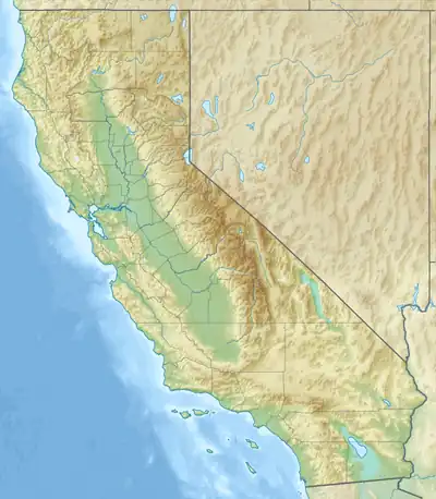 圣安东尼奥山 在加利福尼亚州的位置  圣安东尼奥山 圣安东尼奥山 (美国) | |
| 位置 | |
| 山脈 | 圣盖博山 |
| 地形圖 | 美國地質調查局圣安东尼奥山 |
| 地质 | |
| 山脈類型 | 花崗岩 |
| 攀山 | |
| 最简路线 | 沿索道到达 Baldy Notch、Devil's Backbone Trail (攀登) |
参考资料
外部链接
| 维基共享资源上的相关多媒体资源:圣安东尼奥山 |
- Mt. Baldy Visitor Center and Interpretive Site (页面存档备份,存于). Angeles National Forest.
- Mount San Antonio (Mount Baldy) (页面存档备份,存于). SummitPost.org.
- Destruction at Camp Baldy after the 1938 flood (页面存档备份,存于). Flickr
This article is issued from Wikipedia. The text is licensed under Creative Commons - Attribution - Sharealike. Additional terms may apply for the media files.