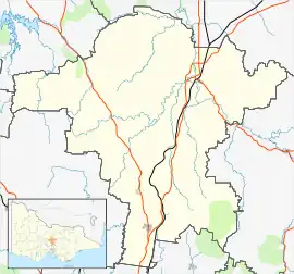
基尔莫尔
基尔莫尔[2](英語:,/ˈkɪlmɔːr/;又译楷模)位于澳大利亞維多利亞州墨爾本以北大約60公里。非常接近休姆高速公路(The Hume Highway)。 近来(2009年),该镇東部遭遇了黑色星期六大火。
| Kilmore | |
|---|---|
 基尔莫尔街景 | |
 Kilmore | |
| 坐标: 37°17′0″S 144°57′0″E | |
| 国家 | |
| 一级行政区 | 維多利亞州 |
| 地方政府区域 | Shire of Mitchell |
| 海拔 | 370 公尺(1,210 英尺) |
| 人口(2016年普查)[1] | |
| • 總計 | 7,958人 |
| 郵政編碼 | 3764 |
| 位置 |
|
| 州選區 | Euroa |
| 聯邦選區 | McEwen |
参考
- Australian Bureau of Statistics. name=Kilmore (State Suburb) 请检查
|url=值 (帮助). 2016 Census QuickStats. 27 June 2017 [13 November 2017]. - . mall.cnki.net. [2022-09-18]. (原始内容存档于2022-09-20).
外部連結
- Kilmore Historical Society (页面存档备份,存于) (英文)
- Kilmore Celtic Festival and Kilmore Mechanics' Institute (页面存档备份,存于) (英文)
- Ferreting, Feasting and Finding Your Way Around Historic Kilmore Country (页面存档备份,存于) (英文)
- Walkabout - Kilmore (英文)
| 维基共享资源中相关的多媒体资源:基尔莫尔 |
This article is issued from Wikipedia. The text is licensed under Creative Commons - Attribution - Sharealike. Additional terms may apply for the media files.