馬林韋德行政區
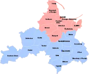
馬林韋德行政區(德語:),是普魯士的一個行政區,首府位於馬林韋德(現稱克維曾(波蘭語:Kwidzyn))。馬林韋德行政區從1815年到1829年是西普魯士省的一部分,在1878-1920年間又是普魯士省的一部分。馬林韋德行政區在1920年至1922年期間被置於同盟國委員會的管理之下,最終被分割,西部地區被納入新成立的波蘭第二共和國,成為所謂的波蘭走廊的一部分。1922年至1939年加入普魯士自由邦東普魯士省,並被魏瑪共和國命名為西普魯士行政區(Regierungsbezirk Westpreußen),此後恢復原名直至1945年[1]。

西普魯士的行政區劃:
但澤行政區
馬林韋德行政區
參考資料
其他
- (德語) Michael Rademacher: Deutsche Verwaltungsgeschichte Preußen, Provinz Westpreußen 的存檔,存档日期20 July 2017. (2006)
- (德語) E. Jacobson: Topographisch-statistisches Handbuch für den Regierungsbezirk Marienwerder, Danzig 1868 (Online, Google).
This article is issued from Wikipedia. The text is licensed under Creative Commons - Attribution - Sharealike. Additional terms may apply for the media files.