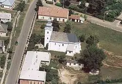
Ófehértó | |
|---|---|
Village (község) | |
 | |
 Coat of arms | |
 Location of Nograd County in Hungary | |
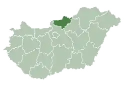
 Ófehértó Location of Ófehértó in Hungary | |
| Coordinates: 47°56′13″N 22°02′10″E / 47.93694°N 22.03611°E | |
| Country | |
| Region | Northern Hungary |
| County | Szabolcs-Szatmár-Bereg County |
| District | Baktalórántháza |
| Government | |
| • Mayor | Simon József (Fidesz-KDNP) |
| Area | |
| • Total | 43.17 km2 (16.67 sq mi) |
| Population (1 Jan. 2015) | |
| • Total | 2,551 |
| • Density | 59/km2 (150/sq mi) |
| Time zone | UTC+1 (CET) |
| • Summer (DST) | UTC+2 (CEST) |
| Postal code | 4558 |
| Area code | 42 |
| Website | http://ofeherto.hu/ |
Ófehértó is a village in Szabolcs-Szatmár-Bereg County, Hungary.[1]
References
- ↑ "Central Statistical Office". KSH. Retrieved 23 December 2017.


This article is issued from Wikipedia. The text is licensed under Creative Commons - Attribution - Sharealike. Additional terms may apply for the media files.