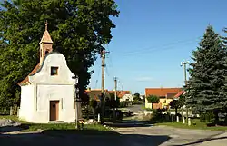
Čejetice | |
|---|---|
 Common in Čejetice | |
 Flag  Coat of arms | |
 Čejetice Location in the Czech Republic | |
| Coordinates: 49°15′10″N 14°1′13″E / 49.25278°N 14.02028°E | |
| Country | |
| Region | South Bohemian |
| District | Strakonice |
| First mentioned | 1289 |
| Area | |
| • Total | 21.04 km2 (8.12 sq mi) |
| Elevation | 377 m (1,237 ft) |
| Population (2023-01-01)[1] | |
| • Total | 912 |
| • Density | 43/km2 (110/sq mi) |
| Time zone | UTC+1 (CET) |
| • Summer (DST) | UTC+2 (CEST) |
| Postal code | 386 01 |
| Website | www |
Čejetice is a municipality and village in Strakonice District in the South Bohemian Region of the Czech Republic. It has about 900 inhabitants.
Administrative parts
Villages of Mladějovice, Sedlíkovice, Sedliště and Sudoměř are administrative parts of Čejetice.
Geography
Čejetice is located about 8 kilometres (5 mi) east of Strakonice and 44 km (27 mi) northwest of České Budějovice. It lies in the České Budějovice Basin. The highest point is the hill Virotín at 497 metres (1,631 ft) above sea level. The municipal territory is very rich in fish ponds, the establishment of which has a long history here.
History

The first written mention of Čejetice is from 1289.[2]
Sudoměř is known for the Battle of Sudoměř, which took place between the ponds Škaredý and Markovec during the Hussite Wars in 1420.
Sights
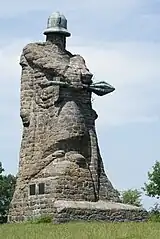
There is the Memorial to Battle of Sudoměř, which is a 16 metres (52 ft) tall stone statue of Jan Žižka. It was created in 1925.[3]
Twin towns – sister cities
.svg.png.webp) Oberwil im Simmental, Switzerland
Oberwil im Simmental, Switzerland
References
- ↑ "Population of Municipalities – 1 January 2023". Czech Statistical Office. 2023-05-23.
- ↑ "Historie" (in Czech). Obec Čejetice. Retrieved 2022-08-26.
- ↑ "Socha Jana Žižky z Trocnova u Sudoměře" (in Czech). CzechTourism. Retrieved 2021-09-13.
- ↑ "Návštěva v partnerské obci Oberwil" (in Czech). Obec Čejetice. 2018. Retrieved 2020-08-23.