Tchořovice | |
|---|---|
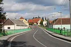 Centre of Tchořovice | |
 Flag  Coat of arms | |
 Tchořovice Location in the Czech Republic | |
| Coordinates: 49°26′14″N 13°48′36″E / 49.43722°N 13.81000°E | |
| Country | |
| Region | South Bohemian |
| District | Strakonice |
| First mentioned | 1321 |
| Area | |
| • Total | 10.24 km2 (3.95 sq mi) |
| Elevation | 454 m (1,490 ft) |
| Population (2023-01-01)[1] | |
| • Total | 230 |
| • Density | 22/km2 (58/sq mi) |
| Time zone | UTC+1 (CET) |
| • Summer (DST) | UTC+2 (CEST) |
| Postal code | 388 01 |
| Website | www |
Tchořovice is a municipality and village in Strakonice District in the South Bohemian Region of the Czech Republic. It has about 200 inhabitants.
Tchořovice lies approximately 20 kilometres (12 mi) north of Strakonice, 70 km (43 mi) north-west of České Budějovice, and 85 km (53 mi) south-west of Prague.
References
Wikimedia Commons has media related to Tchořovice.
This article is issued from Wikipedia. The text is licensed under Creative Commons - Attribution - Sharealike. Additional terms may apply for the media files.