Červený Újezd | |
|---|---|
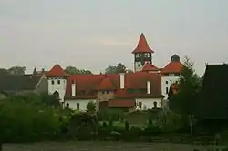
 Museum built as a castle | |
 Flag  Coat of arms | |
 Červený Újezd Location in the Czech Republic | |
| Coordinates: 50°4′11″N 14°9′58″E / 50.06972°N 14.16611°E | |
| Country | |
| Region | Central Bohemian |
| District | Prague-West |
| First mentioned | 1318 |
| Area | |
| • Total | 5.34 km2 (2.06 sq mi) |
| Elevation | 401 m (1,316 ft) |
| Population (2023-01-01)[1] | |
| • Total | 1,626 |
| • Density | 300/km2 (790/sq mi) |
| Time zone | UTC+1 (CET) |
| • Summer (DST) | UTC+2 (CEST) |
| Postal code | 273 51 |
| Website | www |
Červený Újezd is a municipality and village in Prague-West District in the Central Bohemian Region of the Czech Republic. It has about 1,600 inhabitants.
Geography
Červený Újezd is located about 11 km (7 mi) west of Prague. It lies in an agricultural landscape on the border between the Prague Plateau and Křivoklát Highlands.
History
The first written mention of Červený Újezd is from 1318.[2]
Sights
In the local part named Hájek is located a pilgrimage site with a Franciscan monastery. The oldest part of the early Baroque complex is a Loretan chapel, built in 1623–1625. The monastery was then added to the chapel in 1663–1681.[3] Hájek is the destination of the pilgrimage starting in Prague-Břevnov.[4]
In 2001, an artificial castle was built in Červený Újezd. It houses a museum, but it also serves cultural and social purposes. There is a small open-air museum in the castle's gardens.[5]
References
- ↑ "Population of Municipalities – 1 January 2023". Czech Statistical Office. 2023-05-23.
- ↑ "Historie obce" (in Czech). Obec Červený Újezd. Retrieved 2022-08-21.
- ↑ "Klášter sv. Františka" (in Czech). National Heritage Institute. Retrieved 2023-03-06.
- ↑ "Poutní cesta z Prahy do Hájku" (in Czech). National Heritage Institute. Retrieved 2023-03-06.
- ↑ "Hrad Červený Újezd" (in Czech). CzechTourism. Retrieved 2023-03-06.