Zlatníky-Hodkovice | |
|---|---|
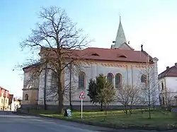
 Church of Saints Peter and Paul | |
 Flag  Coat of arms | |
 Zlatníky-Hodkovice Location in the Czech Republic | |
| Coordinates: 49°57′36″N 14°28′53″E / 49.96000°N 14.48139°E | |
| Country | |
| Region | Central Bohemian |
| District | Prague-West |
| First mentioned | 1300 |
| Area | |
| • Total | 7.65 km2 (2.95 sq mi) |
| Elevation | 361 m (1,184 ft) |
| Population (2023-01-01)[1] | |
| • Total | 1,398 |
| • Density | 180/km2 (470/sq mi) |
| Time zone | UTC+1 (CET) |
| • Summer (DST) | UTC+2 (CEST) |
| Postal code | 252 41 |
| Website | www |
Zlatníky-Hodkovice is a municipality in Prague-West District in the Central Bohemian Region of the Czech Republic. It has about 1,400 inhabitants.
Administrative parts
The municipality is made up of villages of Zlatníky and Hodkovice.
Geography
Zlatníky-Hodkovice is located south of Prague, in its immediate vicinity. It lies in a flat agricultural landscape of the Prague Plateau.
History
The first written mention of Zlatníky is from 1300 and of Hodkovice from 1314.[2]
In 1961, the formerly independent municipality of Hodkovice was joined to Zlatníky as its administrative part. Since 1999, the municipality has its current name.[3]
Transport
The D0 motorway (part of the European route E50) passes through the northern part of the municipality.
Sights
The main landmark of the municipality is the Church of Saints Peter and Paul in Zlatníky. The original church was first documented in 1377. The current Neo-Romanesque building replaced the old church in 1857.[4]
References
- ↑ "Population of Municipalities – 1 January 2023". Czech Statistical Office. 2023-05-23.
- ↑ "Historie a turistické zajímavosti obce" (in Czech). Obec Zlatníky-Hodkovice. Retrieved 2023-05-31.
- ↑ "Historický lexikon obcí České republiky 1869–2011" (in Czech). Czech Statistical Office. 2015-12-21. pp. 144, 667.
- ↑ "Zlatníky-Hodkovice, kostel sv. Petra a Pavla" (in Czech). Noc kostelů. Retrieved 2023-05-31.