 | |
.jpg.webp) | |
| UTC time | 1929-01-17 11:45:42 |
|---|---|
| ISC event | 907860 |
| USGS-ANSS | ComCat |
| Local date | January 17, 1929 |
| Local time | 7:45 VET |
| Duration | 30 seconds |
| Magnitude | 6.7 Mw |
| Depth | 10.0 km |
| Epicenter | 10°32′35″N 64°26′38″W / 10.543°N 64.444°W |
| Type | Strike-slip |
| Areas affected | Venezuela |
| Max. intensity | IX (Violent) |
| Tsunami | 3 m (9.8 ft) |
| Casualties | 200–1,600 dead, 800 injured |
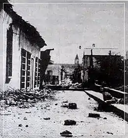
The 1929 Cumaná earthquake occurred on January 17 at 07:45:44 local time, affecting Venezuela. Measuring 6.7 on the moment magnitude scale (Mw ) at a depth of 10 km (6.2 mi),[1] the earthquake severely damaged the city of Cumaná in Sucre state. The earthquake had an epicenter located offshore in the Caribbean Sea, and had a maximum Modified Mercalli intensity scale rating of IX (Violent).[2] It lasted 30 seconds,[3][4] causing major damage and a tsunami. More than 200 people were killed although the finalized death toll is unknown; possibly 1,600.
Earthquake
The earthquake was associated with strike-slip faulting at a shallow depth; a common characteristic for earthquakes of this depth in the region of northern Venezuela.[5] It is one of the most extensively studied earthquakes in Venezuela prior to 1997.[2] The El Pilar Fault System, a right-lateral strike-slip fault extending 350 kilometres (220 mi) from the Cariaco Basin to the Paria Peninsula is thought to be the source of the event. The earthquake in 1929 is thought to have ruptured approximately 30–40 kilometres (19–25 mi) of the fault.[6][7] Most of the surface rupture was offshore, and only 4 kilometres (2.5 mi) of it was visible at the surface, extending east–west.[2] The surface-wave magnitude (Ms ) was calculated to be 6.3; a revision of 6.9 which was considered an overestimation. The same fault segment is thought to have partially ruptured during the 1997 Cariaco earthquake, which occurred east of the 1929 event. It is believed that the 1929 earthquake ruptured a segment that was involved in a 1797 event.[2]
Tsunami
At the coast of Cumaná, in Puerto De Sucre, survivors witnessed the a drawback of the sea by as much as 200 meters. The tsunami reportedly swept away some homes located along the shore, killing some 40 individuals. The maximum tsunami height was measured at 3 metres (9.8 ft).[8] Cumaná suffered severe damage from the tsunami, and the waves were recorded in four other cities. Two launches, each weighing 5-tons were carried and dumped inland. Boats were destroyed.[9]
Impact
The earthquake razed to the ground more than 3,500 homes in Cumaná. The shaking which lasted 30 seconds, severely damaged a theater, which has now been converted to a cathedral. The Church of Santa Inés suffered partial destruction of its structure, as well as to the San Antonio de la Eminencia castle. A clock tower on the Church of Santa Inés stopped working at the time the earthquake struck. After the earthquake, new towers were built around the church during restoration works. Ground collapse and landslides were reported.[9] The earthquake was also felt in Barcelona, Margarita, Güiria, Carúpano, Río Caribe, Caracas, and Irapa.[10] No official figure for the death toll exists, although it has been estimated to be as much as eight percent of the population of 20,000.[11] At least 800 people were injured.
See also
References
- ↑ ISC (2022), ISC-GEM Global Instrumental Earthquake Catalogue (1900–2009), Version 9.1, International Seismological Centre
- 1 2 3 4 Audemard, Franck A. (2007). "Revised seismic history of the El Pilar fault, Northeastern Venezuela, from the Cariaco 1997 earthquake and recent preliminary paleoseismic results". Journal of Seismology. 11 (3): 311–326. Bibcode:2007JSeis..11..311A. doi:10.1007/s10950-007-9054-2. S2CID 129302616.
- ↑ "The 1997, Cariaco, Eastern Venezuela Earthquake" (EERI Special Earthquake Report). Earthquake Engineering Research Institute. October 1997. Retrieved 1 September 2021.
- ↑ "CUMANA VICTIMS TELL QUAKE STORY". The New York Times Archives. Associated Press. 20 January 1929. p. 6.
- ↑ Diane I. Doser; Shelley R. Vandusen (1996). "Source processes of large (M≥6.5) earthquakes of the Southeastern Caribbean (1926–1960)" (PDF). Pure and Applied Geophysics. 146 (1): 43–66. Bibcode:1996PApGe.146...43D. doi:10.1007/BF00876669. S2CID 129667818.
- ↑ F.A. Audemard, M.N. Machette, J.W. Cox, R.L. Dart, K.M. Haller (2000). "Map and Database of Quaternary Faults in Venezuela and its Offshore Regions" (PDF). Open-File Report. U.S. Geological Survey. doi:10.3133/ofr0018.
{{cite book}}: CS1 maint: multiple names: authors list (link) - ↑ Mocquet A.; Beltran C.; Lugo M.; Rodriguez J. A.; Singer A. (1996). "Seismological interpretation of the historical data related to the 1929 Cumana earthquake, Venezuela" (PDF). Andean Geodynamics: Extended Abstracts. ISSN 0767-2896.
- ↑ Mirna Guevara (2014). "SIMULACIÓN NUMÉRICA DEL TSUNAMI ASOCIADO ALTERREMOTO DEL 17 DE ENERO DE 1929 EN LA CIUDAD DECUMANÁ, UNA CONTRIBUCIÓN A LOS ESTUDIOS DE RIESGO ENLAS COSTAS VENEZOLANAS" [NUMERICAL SIMULATION OF THE TSUNAMI ASSOCIATED WITH THEEARTHQUAKE OF JANUARY 17, 1929 IN THE CITY OFCUMANÁ, A CONTRIBUTION TO RISK STUDIES IN THE VENEZUELAN COASTS] (PDF) (in Spanish). Caracas, Venezuela.
{{cite journal}}: Cite journal requires|journal=(help) - 1 2 James F. Lander; Lowell S. Whiteside; Patricia A. Lockridge (2002). "A brief of tsunamis in the Caribbean Sea" (PDF). Science of Tsunami Hazards. 20 (2): 57-94.
- ↑ Zoraida Pereira (2002). La Investigación Sismológica en Venezuela (in Spanish). Caracas, Venezuela: Impresos Lauper. ISBN 980-6069-11-0.
- ↑ "TERREMOTO DE CUMANÁ". Sucre Turística. Retrieved 1 September 2021.