Abbey Junction | |
|---|---|
_geograph-3222246-by-Ben-Brooksbank.jpg.webp) The station site years after closure | |
| General information | |
| Location | Abbey Town, Allerdale England |
| Platforms | ? |
| Other information | |
| Status | Disused |
| History | |
| Original company | Solway Junction Railway |
| Pre-grouping | Caledonian Railway |
| Key dates | |
| 1856 | Station opened as Abbeyholme |
| 31 August 1870 | Station opened as Abbey Junction |
| 1 January 1917 | Closed |
| 2 March 1919 | Reopened |
| 1 September 1921 | Closed |
Carlisle and Silloth Bay Railway | ||||||||||||||
|---|---|---|---|---|---|---|---|---|---|---|---|---|---|---|
| ||||||||||||||
Abbey Junction railway station was the railway junction where the branch line to Silloth on the Solway Firth divided from the Solway Junction Railway in the English county of Cumberland (later Cumbria).[1]
History

A 1903 Railway Clearing House Junction Diagram showing (right) railways in the vicinity of Abbey Junction
A station on the site was opened as Abbeyholme by the Carlisle and Silloth Bay Railway in 1856, and was then renamed Abbey Junction by the North British Railway in 1870. It closed in 1921.
A parallel station on the site was opened as Abbey Junction by the Maryport and Carlisle Railway. It closed briefly from 1917 to 1919 then permanently in 1921.
The closure of the stations was linked to the closure of the Solway viaduct.

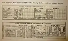
Extracts from Bradshaw's Guide, April 1910 showing the two lines which crossed at Abbey Junction, Cumberland
References
- ↑ Robinson 2002, pp. 5–6.
Sources
- Butt, R. V. J. (October 1995). The Directory of Railway Stations: details every public and private passenger station, halt, platform and stopping place, past and present (1st ed.). Sparkford: Patrick Stephens Ltd. ISBN 978-1-85260-508-7. OCLC 60251199. OL 11956311M.
- Jowett, A. (2000). Jowett's Nationalised Railway Atlas. Atlantic Publishing. ISBN 0-906899-99-0.
- Robinson, Peter W. (2002). Cumbria's Lost Railways. Catrine: Stenlake Publishing. ISBN 978-1-84033-205-6.
External links
- The station on a navigable Edwardian 6" OS map, via National Library of Scotland
- Carlisle & Silloth Bay Railway
- The line with period photographs, via Holme St Cuthbert History Group (archive copy)
- The station via Rail Map Online
| Preceding station | Disused railways | Following station | ||
|---|---|---|---|---|
| Sleightholme Line and station closed |
North British Railway Carlisle and Silloth Bay Railway |
Kirkbride Line and station closed | ||
| Whitrigg Line and station closed |
Caledonian Railway Solway Junction Railway |
Bromfield Line and station closed |
This article is issued from Wikipedia. The text is licensed under Creative Commons - Attribution - Sharealike. Additional terms may apply for the media files.