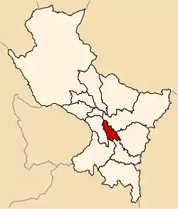
Acomayo | |
|---|---|
 Location of Acomayo in the Cusco Region | |
| Country | Peru |
| Region | Cusco |
| Capital | Acomayo |
| Government | |
| • Mayor | Moises Ramos Villares (2007) |
| Area | |
| • Total | 948.22 km2 (366.11 sq mi) |
| Population (2005 census) | |
| • Total | 27,704 |
| • Density | 29/km2 (76/sq mi) |
| UBIGEO | 0802 |
Acomayo Province is one of thirteen provinces in the Cusco Region in the southern highlands of Peru.
Geography
Some of the highest mountains of the province are listed below:[1]
- Anka Tiyana
- Awaq Pata
- Ayawiri
- Hatun Ñan
- Hatun Urqu
- Inti Qhawarina
- Kunka
- Kunkayuq
- Kuntur Sayana
- Kuntur Sinqa
- Kuyu Urqu
- Llaqta K'uchu
- Maranniyuq
- Mawk'a Llaqta
- Milla Punta
- Nina Urqu
- Pariwana
- Pitu Urqu
- Pisqu Urqu
- Puka Kancha
- Pukara
- Pukarani
- Qucha Kunka
- Qullqi Marka
- Qurpa Kancha
- Q'ara Kunka
- Q'illuma Q'asa
- Q'iru Chimpa
- Runtu Marka
- Sillu Qaqa
- T'aqa Raqay
- T'aqta Urqu
- Uqlla Q'asa
- Wanu Kunka
- Waqra Pukara
- Wayllani
- Yuthu Q'asa
Political division
The province is divided into seven districts (Spanish: distritos, singular: distrito), each of which is headed by a mayor (alcalde). The districts, with their capitals in parentheses, are:
- Acomayo (Acomayo)
- Acopia (Acopia)
- Acos (Acos)
- Mosoc Llacta (Mosoc Llacta)
- Pomacanchi (Pomacanchi)
- Rondocan (Rondocan)
- Sangarará (Sangarará)
Ethnic groups
The people in the province are mainly indigenous citizens of Quechua descent. Quechua is the language which the majority of the population (87.48%) learnt to speak in childhood, 12.25% of the residents started speaking in Spanish.[2]
See also
- Acomayo (Cusco)
- Lake Asnacocha
- Pumaqanchi Lake
- Waqra Pukara
Sources
- ↑ escale.minedu.gob.pe - UGEL map of the Acomayo Province (Cusco Region)
- ↑ inei.gob.pe Archived 2013-01-27 at the Wayback Machine INEI, Peru, Censos Nacionales 2007
13°55′08″S 71°41′06″W / 13.91889°S 71.68500°W
This article is issued from Wikipedia. The text is licensed under Creative Commons - Attribution - Sharealike. Additional terms may apply for the media files.