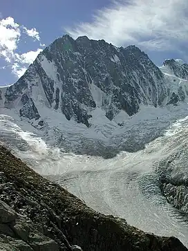
| Aiguille de Leschaux | |
|---|---|
 Aiguille de Leschaux | |
| Highest point | |
| Elevation | 3,759 m (12,333 ft)[1] |
| Prominence | 316 m (1,037 ft)[2] |
| Listing | Alpine mountains above 3000 m |
| Coordinates | 45°53′14″N 07°00′24″E / 45.88722°N 7.00667°E |
| Geography | |
 Aiguille de Leschaux | |
| Parent range | Mont Blanc Massif, Graian Alps |
Aiguille de Leschaux (Italian: Aiguille de Leschaux) (3,759 m) is a mountain in the Mont Blanc massif on the border of Haute-Savoie, France and Aosta Valley, Italy.
Located on the eastern side of the Mont Blanc massif on the ridge between Mont Dolent and Grandes Jorasses, the mountain is usually climbed from Val Ferret on the Italian side. The nearest town is Courmayeur.[3]
References
- ↑ AIGUILLE DE LESCHAUX m. 3.759, www.montagneinvalledaosta.com
- ↑ "Aiguille de Leschaux". peakbagger.com. Retrieved 6 November 2019.
- ↑ "Summitpost - Aiguille de Leschaux". summitpost.org. Retrieved 6 November 2019.
![]() Media related to Aiguille de Leschaux at Wikimedia Commons
Media related to Aiguille de Leschaux at Wikimedia Commons
This article is issued from Wikipedia. The text is licensed under Creative Commons - Attribution - Sharealike. Additional terms may apply for the media files.


