Ampefy | |
|---|---|
 Ampefy Location in Madagascar | |
| Coordinates: 19°02′31″S 46°43′58″E / 19.04194°S 46.73278°E | |
| Country | |
| Region | Itasy |
| District | Soavinandriana |
| Elevation | 1,288 m (4,226 ft) |
| Population (2018)[2] | |
| • Total | 19,949 |
| • Ethnicities | Merina |
| Time zone | UTC3 (EAT) |
| Postal code | 118 |
Ampefy is a municipality in Madagascar. It belongs to the district of Soavinandriana, which is a part of Itasy Region. The population of the commune was 19,949 in 2018.

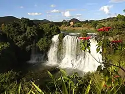
Lily waterfalls near Ampefy

The Analavory geyser is a tourist attraction near Ampefy
Primary and junior level secondary education are available in town. The majority 91.5% of the population of the commune are farmers. The most important crops are beans and vegetables; also maize is an important agricultural product. Industry and services provide employment for 0.5% and 1% of the population, respectively. Additionally fishing employs 7% of the population.[3]
Roads
It is localized on the National Road 43.
Rivers
The Lily River that forms also the Lily falls near Ampefy.
Lakes
The Lake Itasy, the forth mayor lake of Madagascar, is partly situated in this municipality.
References
- ↑ Estimated based on DEM data from Shuttle Radar Topography Mission
- ↑ TROISIEME RECENSEMENT GENERAL DE LA POPULATION ET DE L’HABITATION
- ↑ "ILO census data". Cornell University. 2002. Retrieved 2008-04-23.
This article is issued from Wikipedia. The text is licensed under Creative Commons - Attribution - Sharealike. Additional terms may apply for the media files.
