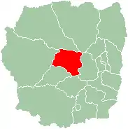
Miarinarivo II | |
|---|---|
 Miarinarivo | |
 Miarinarivo II Location in Madagascar | |
| Coordinates: 18°57′39″S 46°54′00″E / 18.96083°S 46.90000°E | |
| Country | |
| Region | Itasy |
| District | Miarinarivo |
| Population (2018) | |
| • Ethnicities | Merina |
| Time zone | UTC3 (EAT) |
| Postal code | 117 |
Miarinarivo II is a rural municipality in Itasy Region, in the Central Highlands of Madagascar. It covers the villages around the city of Miarinarivo.
Miarinarivo is located at 100 km (62 mi) of Antananarivo and includes the fokontany (villages) of: Ambalalava, Amboalefoka, Ampasamanantongotra, Antanety, Antsahamaina, Antsampanimahazo, Igararana, Manankasina, Miadana and Moraranokely.
Religion
- FJKM – Fiangonan'i Jesoa Kristy eto Madagasikara (Church of Jesus Christ in Madagascar)
- FLM – Fiangonana Loterana Malagasy (Malagasy Lutheran Church)
References
This article is issued from Wikipedia. The text is licensed under Creative Commons - Attribution - Sharealike. Additional terms may apply for the media files.
