Araguacema | |
|---|---|
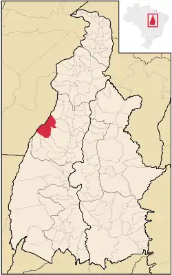 Location in Tocantins state | |
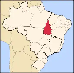
 Araguacema Location in Brazil | |
| Coordinates: 8°48′29″S 49°33′24″W / 8.80806°S 49.55667°W | |
| Country | Brazil |
| Region | North |
| State | Tocantins |
| Mesoregion | Western Meso-region of Tocantins |
| Microregion | Microregion of Miracema do Tocantins |
| Government | |
| • Mayor | Isabella Alves Simas (Democrats) |
| Area | |
| • Total | 2,778 km2 (1,073 sq mi) |
| Population (2020 [1]) | |
| • Total | 7,155 |
| • Density | 2.6/km2 (6.7/sq mi) |
| Time zone | UTC−3 (BRT) |
| Postal code | 77690-000 |
| Area code | +55 63 |
| Website | http://www.araguacema.to.gov.br/ |
Araguacema is a municipality located in the Brazilian state of Tocantins. Its population was 7,155 (2020) and its area is 2,778 km².[2]
The municipality contains 17.15% of the 1,678,000 hectares (4,150,000 acres) Ilha do Bananal / Cantão Environmental Protection Area, created in 1997.[3]
References
- ↑ "IBGE 2020". Retrieved 26 January 2021.
- ↑ IBGE -
- ↑ APA Leandro (Ilha do Bananal/Cantão) (in Portuguese), ISA: Instituto Socioambiental, retrieved 2016-10-31
This article is issued from Wikipedia. The text is licensed under Creative Commons - Attribution - Sharealike. Additional terms may apply for the media files.