Aranui | |
|---|---|
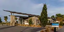
 Aranui shops | |
| Coordinates: 43°30′33″S 172°42′22″E / 43.50917°S 172.70611°E | |
| Country | New Zealand |
| City | Christchurch |
| Local authority | Christchurch City Council |
| Electoral ward | Burwood |
| Community board | Waitai Coastal-Burwood-Linwood |
| Area | |
| • Land | 142 ha (351 acres) |
| Population (June 2023)[2] | |
| • Total | 4,390 |
| Avondale | (Residential red zone) | |
|
|
(Residential red zone) | |
| Wainoni | Bexley |
Aranui is one of the eastern suburbs of Christchurch. It is a lower socio-economic area.[3][4] The area is predominantly residential with pockets of light industry. There is a cluster of shops and service facilities at the intersection of Breezes Road and Pages Road.
Etymology
Aranui is a Māori word, with ara meaning path and nui meaning great.[5]
History
Part of the area was previously called Flemington, named after the hairdresser and tobacconist Jubal Fleming (c.1844–1903).[6][7] Fleming had a subdivision at the corner of Breezes and Pages Roads, and the tram stop on Breezes Road was informally called Flemington. The post office was established in 1912 and it was named Aranui by George Kyngdon Burton (c.1859–1957), with that name then applied to the wider area.[7]
Mabel Howard, New Zealand's first woman cabinet minister, was once a resident in the area.[8]
Geography
Aranui is one of the eastern suburbs. Its eastern boundary is the Avon River. Boundary roads are Pages Road in the south, Breezes Road in the west, and Wainoni Road in the north.[9] Bexley is located to the south of Pages Road.[10] Aranui and its neighbouring suburb of Wainoni are often considered together. For example, Wainoni School and Wainoni Park are located in Aranui, and the Haeata Community Campus is located in Wainoni. Christchurch City Council publishes a combined community profile for the two suburbs.[11]
Demographics
Aranui covers 1.42 km2 (0.55 sq mi).[1] It had an estimated population of 4,390 as of June 2023,[2] with a population density of 3,092 people per km2.
| Year | Pop. | ±% p.a. |
|---|---|---|
| 2006 | 4,260 | — |
| 2013 | 3,777 | −1.70% |
| 2018 | 4,200 | +2.15% |
| Source: [12] | ||

Aranui had a population of 4,200 at the 2018 New Zealand census, an increase of 423 people (11.2%) since the 2013 census, and a decrease of 60 people (−1.4%) since the 2006 census. There were 1,392 households, comprising 2,106 males and 2,091 females, giving a sex ratio of 1.01 males per female. The median age was 30.0 years (compared with 37.4 years nationally), with 1,101 people (26.2%) aged under 15 years, 999 (23.8%) aged 15 to 29, 1,740 (41.4%) aged 30 to 64, and 354 (8.4%) aged 65 or older.
Ethnicities were 66.1% European/Pākehā, 29.9% Māori, 17.6% Pasifika, 3.7% Asian, and 2.0% other ethnicities. People may identify with more than one ethnicity.
The percentage of people born overseas was 13.4, compared with 27.1% nationally.
Although some people chose not to answer the census's question about religious affiliation, 53.9% had no religion, 31.8% were Christian, 2.6% had Māori religious beliefs, 0.7% were Hindu, 0.1% were Muslim, 0.2% were Buddhist and 2.1% had other religions.
Of those at least 15 years old, 153 (4.9%) people had a bachelor's or higher degree, and 1,098 (35.4%) people had no formal qualifications. The median income was $21,300, compared with $31,800 nationally. 96 people (3.1%) earned over $70,000 compared to 17.2% nationally. The employment status of those at least 15 was that 1,224 (39.5%) people were employed full-time, 363 (11.7%) were part-time, and 288 (9.3%) were unemployed.[12]
Education
Aranui is served by the composite school Haeata Community Campus in Wainoni, which was created by a merger of four schools in 2017.[13]
References
- 1 2 "ArcGIS Web Application". statsnz.maps.arcgis.com. Retrieved 30 September 2021.
- 1 2 "Population estimate tables - NZ.Stat". Statistics New Zealand. Retrieved 25 October 2023.
- ↑ "Emergency Relief Centre". grace vinyard church. Archived from the original on 16 April 2011. Retrieved 12 March 2011.
- ↑ "Christchurch Mayor: Nobody has been forgotten". 3 News. 2 March 2011. Retrieved 12 March 2011.
- ↑ Reed, A. W. (2010). Peter Dowling (ed.). Place Names of New Zealand. Rosedale, North Shore: Raupo. p. 27. ISBN 978-0-14-320410-7.
- ↑ "Pars about People". Observer. Vol. XXIII, no. 32. 25 April 1903. p. 4. Retrieved 30 September 2011.
- 1 2 Harper, Margaret (July 2011). "Christchurch Place Names" (PDF). Christchurch City Libraries. Retrieved 30 September 2011.
- ↑ "History". Aranui Community Trust Incorporated Society. Archived from the original on 25 May 2010. Retrieved 12 March 2011.
- ↑ "Boundary Map of Aranui". Statistics New Zealand. Retrieved 4 May 2012.
- ↑ "Boundary Map of Bexley". Statistics New Zealand. Retrieved 4 May 2012.
- ↑ "Community profile Aranui/Wainoni" (PDF). Christchurch City Council. Retrieved 5 October 2013.
- 1 2 "Statistical area 1 dataset for 2018 Census". Statistics New Zealand. March 2020. Aranui (328600). 2018 Census place summary: Aranui
- ↑ "Eight Chch schools merge into two". 3 News NZ. 11 September 2013. Retrieved 30 September 2021.