Highway 149 | ||||
|---|---|---|---|---|
 | ||||
| Route information | ||||
| Maintained by ArDOT | ||||
| Major junctions | ||||
| South end | ||||
| North end | ||||
| Location | ||||
| Country | United States | |||
| State | Arkansas | |||
| Counties | St. Francis, Crittenden, Poinsett | |||
| Highway system | ||||
| ||||
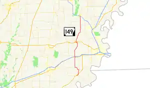
Highway 149 (AR 149, Ark. 149, and Hwy. 149) is a north–south state highway in northeast Arkansas. The route of about 41.28 miles (66.43 km) runs from Highway 38 in Hughes north across Interstate 40 (I-40) and I-555 to AR 140/AR 75/AR 14 in Marked Tree.[1]
Route description

The route begins in Hughes at Highway 38 and runs northeast across US Route 79 (US 79) at North Hughes.[2] Highway 149 continues north to Greasy Corner, where a 3.56-mile (5.73 km) concurrency begins with Highway 50 west along a bayou. After the concurrency ends, Highway 149 turns due north and runs through fields. Another overlap occurs near Shell Lake, where Highway 149 overlaps US 70 for 0.21 miles (0.34 km). US 70/AR 149 run briefly as a frontage road for Interstate 40/US 79 (I-40/US 79) before Highway 149 turns north and runs over the limited-access route. Shortly after this junction the route enters Crittenden County and runs north to Earle.
In Earle Highway 149 has a short officially designated exception over U.S. Route 64B (US 64B). The concurrent routes passes near the Crittenden County Museum, listed on the National Register of Historic Places (NRHP) before Highway 149 turns north onto Barton Street, ending the concurrency.[3] Highway 149 has a junction with US 64 just prior to leaving Earle, and the highway passes the George Berry Washington Memorial (also NRHP-listed) shortly after leaving the city.[3] The road curves through Arkansas delta countryside to a concurrency with Highway 42, beginning at Three Forks.[4] Upon entering Poinsett County, Highway 149 serves as the western terminus of Highway 322 at Mt. Olive. The road continues north to enter Marked Tree, where it has a junction with I-555. It then travels into the town before terminating at AR 140/AR 75/AR 14.
Major intersections
Mile markers reset at concurrencies.
| County | Location | mi[5] | km | Destinations | Notes |
|---|---|---|---|---|---|
| St. Francis | Hughes | 0.00 | 0.00 | Southern terminus | |
| North Hughes | 1.67 | 2.69 | |||
| Greasy Corner | 4.51 | 7.26 | Begin AR 50 concurrency | ||
| | 0.00 | 0.00 | End AR 50 concurrency | ||
| Shell Lake | 7.10 | 11.43 | Begin US 70 concurrency, frontage road for I-40 | ||
| 0.00 | 0.00 | End US 70 concurrency | |||
| | 0.20 | 0.32 | |||
| Crittenden | Earle | 10.74 | 17.28 | Begin US 64B concurrency | |
| 11.20 | 18.02 | End US 64B concurrency | |||
| 11.55 | 18.59 | ||||
| Three Forks | 16.15 | 25.99 | Begin AR 42 concurrency | ||
| | 19.16 | 30.84 | End AR 42 concurrency | ||
| Poinsett | Mt. Olive | 27.30 | 43.94 | AR 322 western terminus | |
| Marked Tree | 29.67 | 47.75 | |||
| Northern terminus, AR 140 western terminus, northern terminus of AR 75 | |||||
1.000 mi = 1.609 km; 1.000 km = 0.621 mi
| |||||
See also
References
- ↑ General Highway Map, Crittenden County, Arkansas (PDF) (Map). 1:62500. Cartography by Planning and Research Division. Arkansas State Highway and Transportation Department. January 2, 2007. Retrieved July 23, 2012.
- ↑ General Highway Map, St. Francis County, Arkansas (PDF) (Map). 1:62500. Cartography by Planning and Research Division. Arkansas State Highway and Transportation Department. December 15, 2007. Retrieved August 4, 2012.
- 1 2 "National Register Information System". National Register of Historic Places. National Park Service. July 9, 2010.
- ↑ General Highway Map, Crittenden County, Arkansas (PDF) (Map). 1:62500. Cartography by Planning and Research Division. Arkansas State Highway and Transportation Department. May 13, 2009. Retrieved August 4, 2012.
- ↑
External links
![]() Media related to Arkansas Highway 149 at Wikimedia Commons
Media related to Arkansas Highway 149 at Wikimedia Commons
