| Khan As'ad Pasha | |
|---|---|
خَان أَسْعَد بَاشَا | |
 | |
| Alternative names | As'ad Pasha al-Azm Khan |
| General information | |
| Type | Caravanserai, museum |
| Architectural style | Ottoman |
| Location | Damascus, Syria |
| Address | Al-Buzuriyah Souq |
| Construction started | 1751 |
| Completed | 1752 |
| Renovated | 1990s |
| Client | As'ad Pasha al-'Azm |
| Technical details | |
| Floor count | 2 |
| Floor area | 2,500 square metres (27,000 sq ft) |
| Renovating team | |
| Awards and prizes | Aga Khan Award for Architecture |
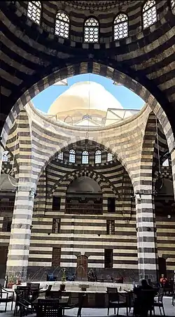
Khan As'ad Pasha (Arabic: خَان أَسْعَد بَاشَا, romanized: Khān ʾAsʿad Bāşā) is the largest caravanserai (khān) in the Old City of Damascus,[1] covering an area of 2,500 square metres (27,000 sq ft). Situated along Al-Buzuriyah Souq, it was built and named after As'ad Pasha al-Azm, the governor of Damascus, in 1751–52.[2] Khan As'ad Pasha has been described as one of the finest khans of Damascus,[3] and the most "ambitious" work of architecture in the city.[4]
Usage

Throughout the Ottoman era, it hosted caravans coming from Baghdad, Mosul, Aleppo, Beirut and elsewhere in the Middle East.[5] Rooms were allowed for renting by notable merchants of the time.[6]
Architecture
The design of the khan included nine small domes and one large central dome reminiscent of Persian architecture, while the nine domes reflect Shia tradition. The covered courtyard features a high ceiling height which helped provide protection from the climate during the hot summer and cold winter seasons.[6]
The restoration of the khān won the Aga Khan Award for Architecture.[7]
Gallery
 The khān, 1836
 Interior
 Interior
 Arches
See also
References
- ↑ Baedeker, 1906, p.307.
- ↑ As'ad Pasha Khan Archived 2011-08-13 at the Wayback Machine Archnet Digital Library.
- ↑ Hillenbrand, 2004, p.355.
- ↑ Carter, 2004, p.90.
- ↑ Thomson, 1886, p.374.
- 1 2 Darke, Diana (2022). The Ottomans: A Cultural Legacy. Thames & Hudson. p. 57. ISBN 978-0-500-77753-4.
- ↑ As'ad Pasha Khan Restoration Archived 2009-01-06 at the Wayback Machine Archnet Digital Library.
Bibliography
- Baedeker, K. (1906). Palestine and Syria: Handbook for Travellers. Baedeker.
- Carter, Terry; Dunston, Lara (2004). Syria & Lebanon. Lonely Planet.
- Hillenbrand, R. (2004). Islamic Architecture: Form, Function, and Meaning. Columbia University Press.
- Thomson, W.M. (1886). The Land and the Book: Or, Biblical Illustrations Drawn from the Manners and Customs, the Scenes and Scenery, of the Holy Land ... Harper & Brothers.
External links
- See inside the place with a virtual tour from the ministry of tourism: https://syriatourism.org/Virtual_Tours/Khan%20Assad%20Basha/