Bang Len Subdistrict
ตำบลบางเลน | |
|---|---|
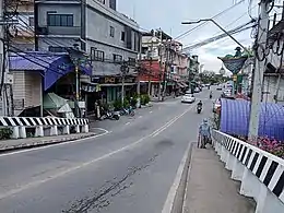
 The western branch of Bang Kruai–Sai Noi Road in the subdistrict | |
| Country | |
| Province | Nonthaburi |
| District | Bang Yai |
| Population | |
| • Total | 19,566 |
| Time zone | UTC+7 (ICT) |
| Postal code | 11140 |
| TIS 1099 | 120303 |
Bang Len (Thai: บางเลน, pronounced [bāːŋ lēːn]) is one of the six subdistricts (tambon) of Bang Yai District, in Nonthaburi Province, Thailand. The subdistrict is bounded by (clockwise from north) Bang Rak Yai, Bang Rak Noi, Bang Krang, Bang Khu Wiang, Bang Muang and Sao Thong Hin subdistricts. In 2020, it had a total population of 19,566 people.[1][2]
Administration
Central administration
The subdistrict is subdivided into 11 administrative villages (muban).[3]
| No. | Name | Thai |
|---|---|---|
| 1. | Ban Bang Len | บ้านบางเลน |
| 2. | Ban Bang Phlu | บ้านบางพลู |
| 3. | Ban Bang Masang | บ้านบางมะซาง |
| 4. | Ban Bang Sakae | บ้านบางสะแก |
| 5. | Ban Tha Rot | บ้านท่ารถ |
| 6. | Ban Na Wat Prang Luang | บ้านหน้าวัดปรางค์หลวง |
| 7. | Ban Wat Yukhantharawat | บ้านวัดยุคันธราวาส |
| 8. | Ban Bang Si Rat | บ้านบางศรีราษฎร์ |
| 9. | Ban Bang Sakae | บ้านบางสะแก |
| 10. | Ban Wat Noi | บ้านวัดน้อย |
| 11. | Ban Na Rong Si | บ้านหน้าโรงสี |
Local administration
The area of the subdistrict is shared by two local administrative organizations.
- Bang Len Subdistrict Municipality (เทศบาลตำบลบางเลน)
- Bang Muang Subdistrict Municipality (เทศบาลตำบลบางม่วง)
References
- 1 2 "Population statistics 2020: Bang Yai District" (in Thai). Department of Provincial Administration. Retrieved 1 December 2021.
- 1 2 "Population statistics 2020: Bang Muang Subdistrict Municipality" (in Thai). Department of Provincial Administration. Retrieved 1 December 2021.
- ↑ ประกาศกระทรวงมหาดไทย เรื่อง การกำหนดเขตตำบลในท้องที่อำเภอบางใหญ่ จังหวัดนนทบุรี (PDF). Royal Gazette (in Thai). 115 (special 34D): 128–153. 6 May 1998. Archived from the original (PDF) on November 14, 2011.
External links
This article is issued from Wikipedia. The text is licensed under Creative Commons - Attribution - Sharealike. Additional terms may apply for the media files.