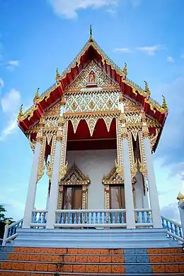
Bang Si Thong Subdistrict
ตำบลบางสีทอง | |
|---|---|
 Wat Sai, a Buddhist temple in the subdistrict | |
| Country | |
| Province | Nonthaburi |
| District | Bang Kruai |
| Area | |
| • Total | 5.8 km2 (2.2 sq mi) |
| Population (2020)[2] | |
| • Total | 11,426 |
| • Density | 1,970/km2 (5,100/sq mi) |
| Time zone | UTC+7 (ICT) |
| Postal code | 11130 |
| TIS 1099 | 120203 |
Bang Si Thong (Thai: บางสีทอง, pronounced [bāːŋ sǐː tʰɔ̄ːŋ]) is one of the nine subdistricts (tambon) of Bang Kruai District, in Nonthaburi Province, Thailand. The subdistrict is bounded by (clockwise from north) Bang Krang, Bang Si Mueang, Bang Phai, Bang Kruai, Wat Chalo and Bang Khanun subdistricts. In 2020, it had a total population of 11,426 people.[2]
Administration
Central administration
The subdistrict is subdivided into 5 administrative villages (muban).[3]
| No. | Name | Thai |
|---|---|---|
| 1. | Ban Wat Sai | บ้านวัดไทร |
| 2. | Ban Wat Bang Oi Chang | บ้านวัดบางอ้อยช้าง |
| 3. | Ban Wat Daeng Pracha Rat | บ้านวัดแดงประชาราษฎร์ |
| 4. | Ban Wat Ruak Bang Si Thong | บ้านวัดรวกบางสีทอง |
| 5. | Ban Bang Si Thong | บ้านบางสีทอง |
Local administration
The whole area of the subdistrict is covered by Bang Si Thong Subdistrict Municipality (เทศบาลตำบลบางสีทอง).[1]
References
- 1 2 Bang Si Thong Subdistrict Municipality (2021). ข้อมูลสภาพทั่วไป. Bang Si Thong Subdistrict Municipality (in Thai). Retrieved 30 November 2021.
- 1 2 "Population statistics 2020" (in Thai). Department of Provincial Administration. Retrieved 30 November 2021.
- ↑ ประกาศกระทรวงมหาดไทย เรื่อง การกำหนดเขตตำบลในท้องที่อำเภอบางกรวย จังหวัดนนทบุรี (PDF). Royal Gazette (in Thai). 115 (special 34D): 104–127. 6 May 1998. Archived from the original (PDF) on November 13, 2011.
External links
This article is issued from Wikipedia. The text is licensed under Creative Commons - Attribution - Sharealike. Additional terms may apply for the media files.