| Big Sheep Mountains | |
|---|---|

| |
| Highest point | |
| Peak | Big Sheep Mountain |
| Elevation | 3,600+ ft (1,100 m)[1] |
| Coordinates | 47°03′15″N 105°43′48″W / 47.05412°N 105.72989°W[1] |
| Geography | |
| Country | United States |
| Region | Montana |
| Range coordinates | 47°18′58″N 105°17′31″W / 47.316°N 105.292°W |
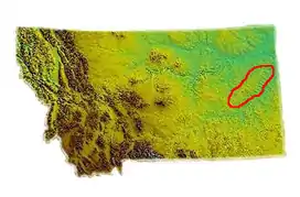
The Big Sheep Mountains are located in the eastern area of the U.S. State of Montana in Prairie County, Montana. They are the easternmost mountains in Montana. Nearby towns include Circle, Lindsay, and Glendive.
See also
References
- 1 2 "Big Sheep Mountain". Peakbagger.com.
This article is issued from Wikipedia. The text is licensed under Creative Commons - Attribution - Sharealike. Additional terms may apply for the media files.