Madison County | |
|---|---|
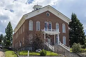 Madison County Courthouse in Virginia City | |
 Location within the U.S. state of Montana | |
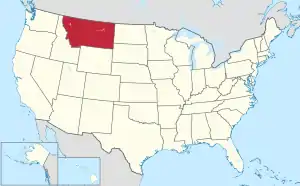 Montana's location within the U.S. | |
| Coordinates: 45°18′N 111°55′W / 45.3°N 111.92°W | |
| Country | |
| State | |
| Founded | 1865 |
| Named for | James Madison[1] |
| Seat | Virginia City |
| Largest town | Ennis |
| Area | |
| • Total | 3,603 sq mi (9,330 km2) |
| • Land | 3,587 sq mi (9,290 km2) |
| • Water | 15 sq mi (40 km2) 0.4% |
| Population (2020) | |
| • Total | 8,623 |
| • Estimate (2022) | 9,265 |
| • Density | 2.4/sq mi (0.92/km2) |
| Time zone | UTC−7 (Mountain) |
| • Summer (DST) | UTC−6 (MDT) |
| Congressional district | 1st |
| Website | www |
| |
Madison County is a county in the U.S. state of Montana. As of the 2020 census, the population was 8,623.[2] Its county seat is Virginia City.[3] The county was founded in 1865;[4] at the time it was part of the Montana Territory.
Geography
According to the United States Census Bureau, the county has an area of 3,603 square miles (9,330 km2), of which 3,587 square miles (9,290 km2) is land and 15 square miles (39 km2) (0.4%) is water.[5]
Major highways
Adjacent counties
- Beaverhead County - southwest
- Silver Bow County - northwest
- Jefferson County - north
- Gallatin County - east
- Fremont County, Idaho - south
National protected areas
- Beaverhead National Forest (part)
- Deerlodge National Forest (part)
- Gallatin National Forest (part)
Politics
In presidential elections, Madison County has historically voted predominantly Republican, with Franklin D. Roosevelt the only Democrat to carry the vote since 1916, the last of the three times he did so being in 1940.
| Year | Republican | Democratic | Third party | |||
|---|---|---|---|---|---|---|
| No. | % | No. | % | No. | % | |
| 2020 | 4,191 | 68.85% | 1,771 | 29.09% | 125 | 2.05% |
| 2016 | 3,297 | 69.51% | 1,180 | 24.88% | 266 | 5.61% |
| 2012 | 3,130 | 69.06% | 1,289 | 28.44% | 113 | 2.49% |
| 2008 | 2,822 | 61.78% | 1,607 | 35.18% | 139 | 3.04% |
| 2004 | 2,868 | 72.92% | 983 | 24.99% | 82 | 2.08% |
| 2000 | 2,656 | 72.65% | 758 | 20.73% | 242 | 6.62% |
| 1996 | 1,984 | 56.77% | 955 | 27.32% | 556 | 15.91% |
| 1992 | 1,415 | 42.89% | 779 | 23.61% | 1,105 | 33.49% |
| 1988 | 2,045 | 68.62% | 878 | 29.46% | 57 | 1.91% |
| 1984 | 2,308 | 75.20% | 708 | 23.07% | 53 | 1.73% |
| 1980 | 2,220 | 70.59% | 676 | 21.49% | 249 | 7.92% |
| 1976 | 1,688 | 64.67% | 870 | 33.33% | 52 | 1.99% |
| 1972 | 1,780 | 68.78% | 669 | 25.85% | 139 | 5.37% |
| 1968 | 1,289 | 56.39% | 734 | 32.11% | 263 | 11.50% |
| 1964 | 1,276 | 53.10% | 1,125 | 46.82% | 2 | 0.08% |
| 1960 | 1,456 | 58.97% | 1,010 | 40.91% | 3 | 0.12% |
| 1956 | 1,662 | 64.24% | 925 | 35.76% | 0 | 0.00% |
| 1952 | 1,993 | 72.42% | 751 | 27.29% | 8 | 0.29% |
| 1948 | 1,300 | 55.15% | 1,006 | 42.68% | 51 | 2.16% |
| 1944 | 1,278 | 55.25% | 1,022 | 44.19% | 13 | 0.56% |
| 1940 | 1,557 | 47.82% | 1,674 | 51.41% | 25 | 0.77% |
| 1936 | 1,006 | 34.81% | 1,819 | 62.94% | 65 | 2.25% |
| 1932 | 1,097 | 36.86% | 1,764 | 59.27% | 115 | 3.86% |
| 1928 | 1,785 | 68.36% | 812 | 31.10% | 14 | 0.54% |
| 1924 | 1,137 | 45.85% | 672 | 27.10% | 671 | 27.06% |
| 1920 | 1,672 | 63.19% | 877 | 33.14% | 97 | 3.67% |
| 1916 | 1,279 | 42.38% | 1,672 | 55.40% | 67 | 2.22% |
| 1912 | 506 | 27.16% | 822 | 44.12% | 535 | 28.72% |
| 1908 | 964 | 46.68% | 1,029 | 49.83% | 72 | 3.49% |
| 1904 | 1,314 | 55.16% | 971 | 40.76% | 97 | 4.07% |
Demographics
| Census | Pop. | Note | %± |
|---|---|---|---|
| 1870 | 2,684 | — | |
| 1880 | 3,915 | 45.9% | |
| 1890 | 4,692 | 19.8% | |
| 1900 | 7,695 | 64.0% | |
| 1910 | 7,229 | −6.1% | |
| 1920 | 7,495 | 3.7% | |
| 1930 | 6,323 | −15.6% | |
| 1940 | 7,294 | 15.4% | |
| 1950 | 5,998 | −17.8% | |
| 1960 | 5,211 | −13.1% | |
| 1970 | 5,014 | −3.8% | |
| 1980 | 5,448 | 8.7% | |
| 1990 | 5,989 | 9.9% | |
| 2000 | 6,851 | 14.4% | |
| 2010 | 7,691 | 12.3% | |
| 2020 | 8,623 | 12.1% | |
| 2022 (est.) | 9,265 | [7] | 7.4% |
| U.S. Decennial Census[8] 1790–1960[9] 1900–1990[10] 1990–2000[11] 2010–2020[2] | |||
2020 census
As of the census of 2020, there were 8,623 people.
2010 census
As of the census of 2010, there were 7,691 people, 3,560 households, and 2,192 families residing in the county. The population density was 2.1 inhabitants per square mile (0.81/km2). There were 6,940 housing units at an average density of 1.9 units per square mile (0.73/km2). The racial makeup of the county was 96.8% white, 0.5% American Indian, 0.3% Asian, 0.2% black or African American, 0.8% from other races, and 1.4% from two or more races. Those of Hispanic or Latino origin made up 2.4% of the population. In terms of ancestry, 31.0% were German, 19.7% were English, 18.9% were Irish, 7.3% were Norwegian, 5.9% were Swedish, 5.0% were Scottish, and 2.9% were American.
Of the 3,560 households, 21.1% had children under the age of 18 living with them, 53.9% were married couples living together, 4.5% had a female householder with no husband present, 38.4% were non-families, and 32.6% of all households were made up of individuals. The average household size was 2.11 and the average family size was 2.67. The median age was 49.8 years.
The median income for a household in the county was $42,998 and the median income for a family was $52,636. Males had a median income of $38,495 versus $28,125 for females. The per capita income for the county was $32,205. About 8.5% of families and 11.6% of the population were below the poverty line, including 16.7% of those under age 18 and 9.8% of those age 65 or over.
Communities
Towns
Census-designated places
Other unincorporated communities
Former communities
Notable person
- Sam V. Stewart, former Montana governor and Supreme Court justice
See also
References
- ↑ Gannett, Henry (1905). The Origin of Certain Place Names in the United States. U.S. Government Printing Office. p. 196.
- 1 2 "State & County QuickFacts". United States Census Bureau. Retrieved May 8, 2023.
- ↑ "Find a County". National Association of Counties. Retrieved June 7, 2011.
- ↑ "Montana Place Names Companion". Montana Place Names From Alzada to Zortman. Montana Historical Society Research Center. Retrieved December 1, 2014.
- ↑ "2010 Census GazetteerFiles". United States Census Bureau. August 22, 2012. Archived from the original on December 5, 2014. Retrieved November 29, 2014.
- ↑ Leip, David. "Atlas of US Presidential Elections". uselectionatlas.org. Retrieved April 3, 2018.
- ↑ "Annual Estimates of the Resident Population for Counties: April 1, 2020 to July 1, 2022". Retrieved May 8, 2023.
- ↑ "U.S. Decennial Census". United States Census Bureau. Retrieved November 29, 2014.
- ↑ "Historical Census Browser". University of Virginia Library. Retrieved November 29, 2014.
- ↑ "Population of Counties by Decennial Census: 1900 to 1990". United States Census Bureau. Retrieved November 29, 2014.
- ↑ "Census 2000 PHC-T-4. Ranking Tables for Counties: 1990 and 2000" (PDF). United States Census Bureau. Archived (PDF) from the original on March 27, 2010. Retrieved November 29, 2014.
- ↑ Cameron MT Google Maps (accessed January 3, 2019)
- ↑ Junction MT Google Maps (accessed January 3, 2019)
- ↑ Laurin MT Google Maps (accessed January 3, 2019)
- ↑ Nevada City, Madison County MT Google Maps (accessed 3 January 2019)
- ↑ Red Bluff MT Google Maps (accessed January 3, 2019)
- ↑ Rochester MT Google Maps (accessed January 3, 2019)
- ↑ Ruby MT Google Maps (accessed January 3, 2019)
- ↑ Sterling MT Google Maps (accessed January 3, 2019)
- ↑ Summit, Madison County MT Google Maps (accessed January 3, 2019)
External links
Places adjacent to Madison County, Montana | ||||||||||||||||
|---|---|---|---|---|---|---|---|---|---|---|---|---|---|---|---|---|
| ||||||||||||||||
Municipalities and communities of Madison County, Montana, United States | ||
|---|---|---|
| Towns | Madison County map | |
| CDPs | ||
| Other communities | ||
| Ghost towns | ||
| Footnotes | ‡This populated place also has portions in an adjacent county or counties | |