Bukhar-Zhyrau | |
|---|---|
District | |
| Бұқар жырау ауданы | |
 Coat of arms | |
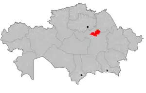 | |
| Country | Kazakhstan |
| Region | Karaganda Region |
| Administrative center | Botakara |
| Founded | 1938 |
| Government | |
| • Akim | Ablay Sultangali[1] |
| Area | |
| • Total | 5,628 sq mi (14,576 km2) |
| Population (2013)[2] | |
| • Total | 63,236 |
| Time zone | UTC+6 (East) |
Bukhar-Zhyrau District (Kazakh: Бұқар жырау ауданы, Būqar Jyrau audany) is a district of Karaganda Region in central Kazakhstan. The administrative center of the district is the settlement of Botakara.[3] Population: 63,236 (2013 estimate);[2] 64,003 (2009 Census results);[4] 69,617 (1999 Census results).[4]
Geography
Bukhar-Zhyrau District lies in the Kazakh Uplands. 1,049 meters (3,442 ft) high mount Semizbughy is the highest point in the district. Rudnichnoye lake is located near it.[5][6]
References
- ↑ "Аблай Султангали назначен акимом Бухар-Жырауского района Карагандинской области". www.inform.kz. 2023-05-18.
- 1 2 "Население Республики Казахстан" (in Russian). Департамент социальной и демографической статистики. Retrieved 27 December 2013.
- ↑ "www.geonames.de Subdivisions of Kazakhstan in local languages". Archived from the original on 2016-03-03. Retrieved 2008-04-22.
- 1 2 "Население Республики Казахстан" [Population of the Republic of Kazakhstan] (in Russian). Департамент социальной и демографической статистики. Retrieved 8 December 2013.
- ↑ "M-43 Topographic Chart (in Russian)". Retrieved 13 October 2022.
- ↑ Google Earth
External links
 Media related to Bukhar-Zhyrau District at Wikimedia Commons
Capital: Karaganda | ||
| Districts |  | |
| Major cities | ||
50°03′30″N 73°43′00″E / 50.05833°N 73.71667°E
This article is issued from Wikipedia. The text is licensed under Creative Commons - Attribution - Sharealike. Additional terms may apply for the media files.