| Burgh Castle | |
|---|---|
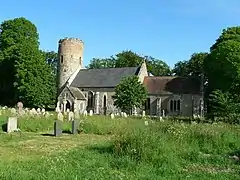
 Church of St Peter and St Paul | |
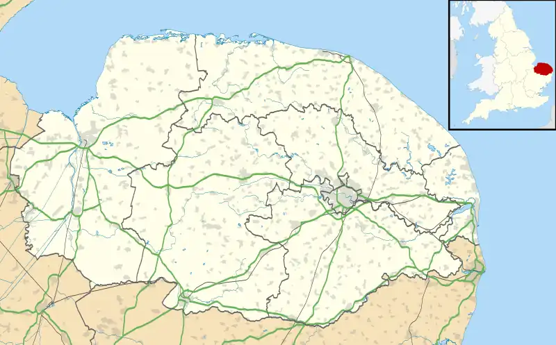
 Burgh Castle Location within Norfolk | |
| Area | 6.76 km2 (2.61 sq mi) |
| Population | 1,150 (2011)[1] |
| • Density | 170/km2 (440/sq mi) |
| OS grid reference | TG476049 |
| Civil parish |
|
| District | |
| Shire county | |
| Region | |
| Country | England |
| Sovereign state | United Kingdom |
| Post town | GREAT YARMOUTH |
| Postcode district | NR31 |
| Police | Norfolk |
| Fire | Norfolk |
| Ambulance | East of England |


Burgh Castle is a village and civil parish in the English county of Norfolk. It is situated on the east bank of the River Waveney, some 3.7 miles (6.0 km) west of Great Yarmouth and within the Norfolk Broads National Park.[2] The parish was part of Suffolk until 1974.[3]
History
Burgh Castle's name is of Roman origin and derives from Gariannonum which invokes the Latin name for the River Yare.[4]
Burgh Castle was likely the site of a Neolithic settlement due to an abundance of flint and bronze axe-heads being discovered in the area.[5][6]
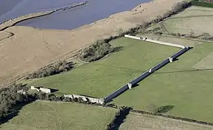
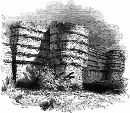
Burgh Castle is the location of a Roman Fortification which dates to the third century; the fort was part of system of coastal defence, the Saxon Shore, against Anglo-Saxon incursions on the East Anglian coast. The site is maintained by the Norfolk Archeological Trust and is open free of charge to the public.[7]
It has been suggested by the Elizabethan historian William Camden, that Burgh Castle is the site of Cnobheresburg, the first Irish monastery in southern England founded by Saint Fursey in the seventh century as part of the Hiberno-Scottish mission.[8]
In the Domesday Book of 1086, Burgh Castle is recorded as consisting of 15 households, belonging to 'Ralph the Bowman.'
Burgh Castle was once used to imprison Eleanor, Fair Maid of Brittany.
St. Peter and St. Paul's Church
Burgh Castle's Parish Church is of Anglo-Saxon origin and is dedicated to Saint Peter and Saint Paul. The church is one of Norfolk's remaining 124 round-tower churches and the majority of the building dates from the Thirteenth and Fifteenth Centuries, however, there are a significant amount of Roman tiles in the building, likely repurposed from the Roman Fort.[9] It has been a Grade II* listed building since November 1954.[10][11]
Local government
In the 2001 census, Burgh Castle had a population of 955 people in 376 households. For the purposes of local government, the parish today falls within the district of Great Yarmouth. However prior to the Local Government Act 1972, the parish was within Lothingland Rural District in Suffolk.[12]
See also
References
- ↑ "Parish population 2011". Retrieved 24 August 2015.
- ↑ Ordnance Survey (2005). OS Explorer Map OL40 - The Broads. ISBN 0-319-23769-9.
- ↑ }Spooner, S. (2005). "Parish Summary: Burgh Castle". norfolk.gov.uk. Retrieved 14 November 2022.
- ↑ "Key to English Place-names". kepn.nottingham.ac.uk. Retrieved 16 November 2022.
- ↑ "mnf31204 - Norfolk Heritage Explorer". www.heritage.norfolk.gov.uk. Retrieved 16 November 2022.
- ↑ "mnf17108 - Norfolk Heritage Explorer". www.heritage.norfolk.gov.uk. Retrieved 16 November 2022.
- ↑ "Burgh Castle Roman Fort". English Heritage. Retrieved 16 November 2022.
- ↑ "Burgh-Castle-(Parish-Summary) - Norfolk Heritage Explorer". www.heritage.norfolk.gov.uk. Retrieved 16 November 2022.
- ↑ Rose, E; Holburn, D. (1996–2011). "Norfolk Heritage Explorer - St Peter and St Paul's Church, Burgh Castle". Retrieved 14 November 2022.
- ↑ Service, Norfolk Historic Environment. "Norfolk Heritage Explorer". www.heritage.norfolk.gov.uk. Retrieved 1 March 2018.
- ↑ Stuff, Good. "Church of St Peter and St Paul, Burgh Castle, Norfolk". www.britishlistedbuildings.co.uk. Retrieved 1 March 2018.
- ↑ Local Government Act 1972, Schedule 1 Part II Non-metropolitan counties.
External links
- Map sources for Burgh Castle
- Gariannum Roman Fort, Roman-Britain.co.uk
- Burgh Castle fort at Norfolk Archaeological Trust
- Burgh Castle at genuki.org.uk
- Burgh Castle at English Heritage
- St Peter's and St Paul's on the European Round Tower Churches Website
- Photographs of the church and fort at flickr.com
- Hursey Pilgrims - Christian pilgrimage to Burgh Castle