Capricorn Highway | |
|---|---|
| General information | |
| Type | Highway |
| Length | 575 km (357 mi) |
| Route number(s) |
|
| Former route number | |
| Major junctions | |
| West end | |
| East end | |
| Location(s) | |
| Major settlements | Jericho, Alpha, Emerald, Blackwater, Gogango, Westwood |
| Highway system | |
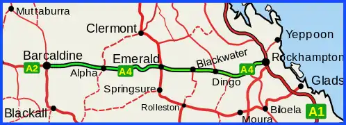
The Capricorn Highway is located in Central Queensland, Australia, and links the city of Rockhampton with western Queensland.[1] The highway is 575 kilometres (357 mi) long, and joins the Landsborough Highway at Barcaldine.[2] Formerly National Route 66, Queensland began to convert to the alphanumeric system much of Australia had adopted in the early-2000s and is now designated as A4. The highway runs parallel with the Tropic of Capricorn, hence its name.
Other towns situated along the highway include (from east to west): Gracemere, Kabra, Stanwell, Westwood, Gogango, Duaringa, Dingo, Bluff, Blackwater, Comet, Emerald, Bogantungan, Alpha and Jericho.
Running virtually east/west, the highway traverses the area known as the Central Highlands, and crosses the Great Dividing Range between Alpha and Jericho.
 Capricorn Highway (green on black)
Northern Australia Roads Program upgrade
The Northern Australia Roads Program announced in 2016 included the following project for the Capricorn Highway.
Highway duplication
The project to duplicate the section between Rockhampton and Gracemere was completed in mid 2021 at a total cost of $75 million.[3] This will facilitate the construction of the south-western entry to the proposed Rockhampton Ring Road.
Northern Australian Beef Roads Upgrade
The Northern Australia Beef Roads Program announced in 2016 included the following project:
Road train access to Rockhampton (stage 2)
The project for upgrading between Gracemere saleyards and the Rockhampton abattoirs to provide access for Type 1 Road Trains was completed by early 2021 at a total cost of $30 million.[4] It involved about 29 kilometres (18 mi) of road improvements on four roads:
- Capricorn Highway – from Saleyards Road at Gracemere to the Bruce Highway roundabout at Rochhampton (7.7 kilometres (4.8 mi)).
- Bruce Highway – from the Capricorn Highway roundabout to the Yaamba Road intersection (8.3 kilometres (5.2 mi)).
- Rockhampton–Yeppoon Road – from the Bruce Highway intersection south-west to the Emu Park Road intersection (2.4 kilometres (1.5 mi).
- Rockhampton–Emu Park Road – from the Rockhampton-Yeppoon Road intersection to St Christophers Chapel Road at Nerimbera (10.2 kilometres (6.3 mi)).
Roads of strategic importance upgrades
The Roads of Strategic Importance initiative, last updated in March 2022, included the following projects for the Capricorn Highway.
Corridor upgrade
A lead project to upgrade the Mount Isa to Rockhampton corridor, including sections of the Capricorn and Landsborough Highways and surrounding state and council roads, at an estimated cost of $237.5 million, was in the planning and scoping stage. Works are expected to include progressive sealing, lane duplications and crossing upgrades.[5]
Intersection upgrade Gregory Highway
A project to upgrade the intersection with the Gregory Highway in Emerald at a cost of $7.9 million is scheduled for completion in mid-2023.[6] This project was targeted for "early works" by the Queensland Government.[7]
Other upgrades
Intersection upgrade
A project to upgrade an intersection in Blackwater, at a cost of $6.24 million, was expected to finish in early 2022.[8]
Pavement strengthening and/or widening
A project to strengthen and widen pavement just east of Emerald, at a cost of $5 million, was expected to finish in mid-2022.[9]
A project to widen pavement east of Alpha, at a cost of $9.65 million, was due for completion in late 2022.[10]
Major intersections
| LGA | Location | km | mi | Destinations | Notes |
|---|---|---|---|---|---|
| Barcaldine | Barcaldine | 0 | 0.0 | south – Blackall | Western end of Capricorn Highway |
| Central Highlands | Emerald | 309 | 192 | Western concurrency terminus with Gregory Highway | |
| 311 | 193 | Eastern concurrency terminus with Gregory Highway | |||
| Dingo | 432 | 268 | |||
| Rockhampton | Westwood | 522.9 | 324.9 | ||
| Rockhampton | 574.6 | 357.0 | south – Mount Larcom | Eastern end of Capricorn Highway. Intersection is approximately 4.1 km from Rockhampton CBD | |
1.000 mi = 1.609 km; 1.000 km = 0.621 mi
| |||||
See also
References
- ↑ "Queensland Government - Department of Transport and Main Roads - Maps". Archived from the original on 19 March 2018. Retrieved 12 July 2022.
- ↑ Hema, Maps (2007). Australia Road and 4WD Atlas (Map). Eight Mile Plains Queensland: Hema Maps. pp. 10–11. ISBN 978-1-86500-456-3.
- ↑ "Capricorn Highway (Rockhampton - Duaringa) Rockhampton to Gracemere Duplication". Department of Infrastructure, Transport, Regional Development and Communications. 18 June 2021. Archived from the original on 17 March 2022. Retrieved 30 March 2022.
- ↑ "Rockhampton Road Network – Road Train Access". Department of Infrastructure, Transport, Regional Development and Communications. 8 April 2021. Archived from the original on 16 March 2022. Retrieved 31 March 2022.
- ↑ "Mount Isa to Rockhampton Corridor Upgrade". Department of Infrastructure, Transport, Regional Development and Communications. 29 March 2022. Archived from the original on 26 April 2022. Retrieved 6 May 2022.
- ↑ "Capricorn Highway and Gregory Highway Intersection Upgrade (Emerald)". Department of Infrastructure, Transport, Regional Development and Communications. 17 May 2021. Archived from the original on 29 April 2022. Retrieved 6 May 2022.
- ↑ "ROSI early works package" (PDF). Queensland Government. 29 April 2020. Archived (PDF) from the original on 27 December 2021. Retrieved 7 May 2022.
- ↑ "Capricorn Highway (Duaringa-Emerald) and Ardurad Road, widen pavement and Blackwater-Rolloston Road, upgrade intersection". Queensland Government. 22 November 2021. Archived from the original on 19 May 2022. Retrieved 1 June 2022.
- ↑ "Capricorn Highway (Duaringa-Emerald), Winton Creek to Agricultural College (Emerald), (Stage1),pavement strengthening and widening". Queensland Government. 28 January 2022. Archived from the original on 1 June 2022. Retrieved 1 June 2022.
- ↑ "Capricorn Highway (Emerald-Alpha), widen pavement". Queensland Government. 28 June 2022. Archived from the original on 1 June 2022. Retrieved 1 June 2022.