Chai Nam
ชัยนาม | |
|---|---|
Subdistrict | |
|
Seal | |
| Country | Thailand |
| Province | Phitsanulok |
| District | Wang Thong |
| Government | |
| • Type | Subdistrict administrative organization (SAO) |
| Area | |
| • Total | 45.6 km2 (17.6 sq mi) |
| Population (2022) | |
| • Total | 6,205 |
| • Density | 136/km2 (350/sq mi) |
| Time zone | UTC+7 (ICT) |
| Postal code | 65130 |
| Calling code | 055 |
| Geocode | 650805 |
| Website | www |
Chai Nam (Thai: ชัยนาม) is a subdistrict in Wang Thong district, Phitsanulok province. It is connected to Highways 11 and 12. In 2022 it had a population of 6,205. The economy is mainly based on agriculture.
Geography
The topography of Chai Nam subdistrict is lowland with mountainous areas in the northern parts of Moo1, Moo7 and Moo8 and part of Moo6. The southernmost part of Khao Noi–Khao Pradu Non-hunting Area is located in Moo1. The subdistrict is located in the lower northern part of Thailand. The subdistrict is bordered to the north by Don Thong subdistrict, Mueang Phitsanulok district, to the east by Wang Nok Aen subdistrict, Wang Thong district, to the south by Din Thong subdistrict, Wang Thong district, to the west by Din Thong and Wang Thong subdistricts, Mueang Phitsanulok district.[1] The Wang Thong River flows through the subdistrict and lies in the Nan Basin, which is part of the Chao Phraya Watershed. The subdistrict has connections with highway 12 and to the nearby highway 11.[2]
Administration
Central government
The administration of Chai Nam subdistrict is responsible for an area that covers 28,500 rai ~ 45.6 square kilometres (17.6 sq mi) and consists of nine administrative villages, as of 2022: 6,205 people.[3]
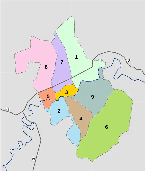
| Village | English | Thai | People |
|---|---|---|---|
| Moo1 | Ban Chai Nam | บ้านไชยนาม | 791 |
| Moo2 | Ban Wang Bon | บ้านวังบอน | 923 |
| Moo3 | Ban Bueng Phrao | บ้านบึงพรัาว | 917 |
| Moo4 | Ban Tha Prong | บ้านท่าโปร่ง | 905 |
| Moo5 | Ban Tao It | บ้านเตาอิฐ | 498 |
| Moo6 | Ban Sam Bon | น้ำนซำบอน | 165 |
| Moo7 | Ban Noen Khli | บ้านเนินคลี | 609 |
| Moo8 | Ban Rong Som Muang | บ้านรัองสัมมวง | 776 |
| Moo9 | Ban Khlong Na Mueang | บ้านคลองนาเมื่ยง | 621 |
Local government
Chai Nam is a subdistrict administrative organization - SAO (Thai: องค์การบริหารส่วนตำบลชัยนาม, romanized: ongkan borihan suan tambon Chai Nam, abbreviated: อบต.ชัยนาม, o bo toh Chai Nam), which covers the whole tambon Chai Nam.
Temples
Chai Nam subdistrict is home to the following active temples, where Theravada Buddhism is practiced by local residents.[4]
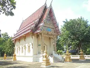
| Temple name | Thai | Location |
|---|---|---|
| Wat Chaiyanam | วัดไชยนาม | Moo1 |
| Wat Koh Kaew Prachanurak | วัดเกาะแก้วประชานุรักษ์ | Moo2 |
| Wat Bueng Phrao | วัดบึงพร้าว | Moo3 |
Economy
The majority of people, about 80 percent, work in agriculture: growing rice, fruit orchards and vegetable crops.[5]
Education
The following elementary/secondary schools are located in Chai Nam.[6]
- Rat Upatham school - Moo2
- Ban Bueng Phrao school - Moo7
- Wang Thong Phithayakhom school - Moo7
Healthcare
There is Chai Nam health-promoting hospital in Moo3.[7]
Transportation
The subdistrict is connected to highways 11 southbound (Nakhon Sawan route), 12 westbound (Tak route) and 12 eastbound (Khon Kaen route).
References
- ↑ "contact territory". Retrieved 21 November 2023.
- ↑ "terrain". Retrieved 21 November 2023.
- ↑ "official statistics registration system". Department of Provincial Administration. Retrieved 21 November 2023, >year 2022 >village level >Excel file >no.65081001-65081009 >Excel line 71250-71258
{{cite web}}: CS1 maint: postscript (link) - ↑ "list of temples". Retrieved 21 November 2023, >no.365081001 - 365081004
{{cite web}}: CS1 maint: postscript (link) - ↑ "population occupation". Retrieved 21 November 2023.
- ↑ "education in the subdistrict". Retrieved 21 November 2023.
- ↑ "public health". Retrieved 21 November 2023.