Chenebier | |
|---|---|
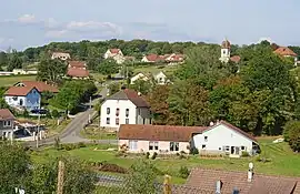 A general view of Chenebier | |
.svg.png.webp) Coat of arms | |
Location of Chenebier | |
 Chenebier  Chenebier | |
| Coordinates: 47°38′32″N 6°43′10″E / 47.6422°N 6.7194°E | |
| Country | France |
| Region | Bourgogne-Franche-Comté |
| Department | Haute-Saône |
| Arrondissement | Lure |
| Canton | Héricourt-2 |
| Intercommunality | CC pays d'Héricourt |
| Government | |
| • Mayor (2020–2026) | Francis Abry[1] |
| Area 1 | 9.05 km2 (3.49 sq mi) |
| Population | 697 |
| • Density | 77/km2 (200/sq mi) |
| Time zone | UTC+01:00 (CET) |
| • Summer (DST) | UTC+02:00 (CEST) |
| INSEE/Postal code | 70149 /70400 |
| Elevation | 346–472 m (1,135–1,549 ft) |
| 1 French Land Register data, which excludes lakes, ponds, glaciers > 1 km2 (0.386 sq mi or 247 acres) and river estuaries. | |
Chenebier (French pronunciation: [ʃənbje]) is a commune in the Haute-Saône department in the region of Bourgogne-Franche-Comté in eastern France.
Around 739 inhabitants live there; they are called "Chenaillots" and "Chenaillottes". Chenebier is surrounded by other villages such as Chagey, Echavanne and Etobon. The closest town is Belfort (department of Territoire de Belfort) and is located 10 kilometers away (North-West). The village lies at some 381 meters elevation and is close to the Ballon des Vosges Natural Park. The mayor is Francis Abry.[1]
See also
References
- 1 2 "Répertoire national des élus: les maires" (in French). data.gouv.fr, Plateforme ouverte des données publiques françaises. 13 September 2022.
- ↑ "Populations légales 2021". The National Institute of Statistics and Economic Studies. 28 December 2023.
Wikimedia Commons has media related to Chenebier.
This article is issued from Wikipedia. The text is licensed under Creative Commons - Attribution - Sharealike. Additional terms may apply for the media files.