Saulnot | |
|---|---|
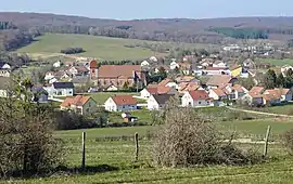 A general view of Saulnot | |
 Coat of arms | |
Location of Saulnot | |
 Saulnot  Saulnot | |
| Coordinates: 47°33′48″N 6°38′03″E / 47.5633°N 6.6342°E | |
| Country | France |
| Region | Bourgogne-Franche-Comté |
| Department | Haute-Saône |
| Arrondissement | Lure |
| Canton | Héricourt-2 |
| Intercommunality | CC pays d'Héricourt |
| Area 1 | 26.73 km2 (10.32 sq mi) |
| Population | 773 |
| • Density | 29/km2 (75/sq mi) |
| Time zone | UTC+01:00 (CET) |
| • Summer (DST) | UTC+02:00 (CEST) |
| INSEE/Postal code | 70477 /70400 |
| Elevation | 324–522 m (1,063–1,713 ft) |
| 1 French Land Register data, which excludes lakes, ponds, glaciers > 1 km2 (0.386 sq mi or 247 acres) and river estuaries. | |
Saulnot is a commune in the Haute-Saône department in the region of Bourgogne-Franche-Comté in eastern France.
Coal mines operated in the village between the 16th century and 1925.
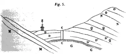 A sectional view of a mine shaft in Saulnot.
 Surface infrastructure of a mine shaft in the start of 20th century.
 View of an open mine shaft.
See also
References
- ↑ "Populations légales 2021". The National Institute of Statistics and Economic Studies. 28 December 2023.
Wikimedia Commons has media related to Saulnot.
This article is issued from Wikipedia. The text is licensed under Creative Commons - Attribution - Sharealike. Additional terms may apply for the media files.