Chraštice | |
|---|---|
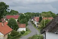 Chraštičky, a part of Chraštice | |
 Chraštice Location in the Czech Republic | |
| Coordinates: 49°34′37″N 14°4′19″E / 49.57694°N 14.07194°E | |
| Country | |
| Region | Central Bohemian |
| District | Příbram |
| First mentioned | 1260 |
| Area | |
| • Total | 6.65 km2 (2.57 sq mi) |
| Elevation | 546 m (1,791 ft) |
| Population (2023-01-01)[1] | |
| • Total | 259 |
| • Density | 39/km2 (100/sq mi) |
| Time zone | UTC+1 (CET) |
| • Summer (DST) | UTC+2 (CEST) |
| Postal code | 262 72 |
| Website | www |
Chraštice is a municipality and village in Příbram District in the Central Bohemian Region of the Czech Republic. It has about 300 inhabitants.
Administrative parts
The village of Chraštičky is an administrative part of Chraštice.
Geography
Chraštice is located about 12 kilometres (7 mi) south of Příbram and 54 km (34 mi) southwest of Prague. It lies in the Benešov Uplands. The highest point is the low hill Skalky at 563 m (1,847 ft) above sea level. There are three ponds in the municipal territory.
History

The first written mention of Chraštice is from 1260.[2]
Transport
The I/4 road, which replaces the unfinished section of the D4 motorway from Prague to Písek, passes through the municipality.
Sights
The landmark of Chraštice is the Church of the Assumption of the Virgin Mary. It is a valuable early Gothic church from the 13th century, which was partly rebuilt in the Baroque style and extended into its current form in 1723–1724.[3]
A historically valuable building is the former fortress from the 14th century, later rebuilt into an inn.[4]
References
- ↑ "Population of Municipalities – 1 January 2023". Czech Statistical Office. 2023-05-23.
- ↑ "Základní informace" (in Czech). Obec Chraštice. Retrieved 2023-02-26.
- ↑ "Kostel Nanebevzetí Panny Marie" (in Czech). National Heritage Institute. Retrieved 2023-02-26.
- ↑ "Chraštická tvrz" (in Czech). Obec Chraštice. Retrieved 2023-02-26.