| Cooloolabin Dam | |
|---|---|
 Cooloolabin Dam in 2021 | |
 Cooloolabin Dam | |
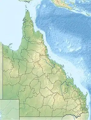
| Location | 12 km (7.5 mi) Northwest of Nambour, Queensland |
| Coordinates | 26°33′01″S 152°52′48″E / 26.5503°S 152.88°E |
| Type | Reservoir |
| Primary inflows | South Maroochy River |
| Catchment area | 8.1 km2 (3.1 sq mi) |
| Basin countries | Australia |
| Surface area | 220 ha (540 acres) |
| Water volume | 8,183 ML (6,634 acre⋅ft) |
Cooloolabin Dam is a concrete gravity dam on Rocky Creek located to the west of Yandina in the headwaters of the South Maroochy River waterway. The main dam wall is 19-metre (62 ft) high and 243 m (797 ft) long, the five saddle dams total 1,100 m (3,600 ft) in length. The dam was completed in 1979 with a capacity of 13,600 ML (11,000 acre⋅ft) and overflowed for the first time in 1988. As part of the seqwater Dam Improvement Program, a section of the spillway was cut away in 2015 to lower the spillway by 3 metres (9.8 ft), reducing the full supply capacity to 8,183 ML (6,634 acre⋅ft).[1][2]
See also
References
- ↑ "Cooloolabin | Seqwater". www.seqwater.com.au. Retrieved 28 October 2021.
- ↑ "Cooloolabin Dam Emergency Action Plan" (PDF). Qld Department of Natural Resources, Mines, and Energy. Archived (PDF) from the original on 13 March 2017.
This article is issued from Wikipedia. The text is licensed under Creative Commons - Attribution - Sharealike. Additional terms may apply for the media files.