Dadu District
| |
|---|---|
  | |
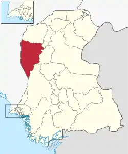 Dadu is located in the west of Sindh | |
| Country | |
| Province | |
| Division | Hyderabad |
| Established | 1931 |
| Founded by | British government |
| Headquarters | Dadu |
| Government | |
| • Type | District Administration |
| • Deputy Commissioner | Syed Murtaza Ali Shah |
| • District Police Officer | N/A |
| • District Health Officer | N/A |
| Area | |
| • Total | 7,866 km2 (3,037 sq mi) |
| Population | |
| • Total | 1,742,320 |
| • Density | 220/km2 (570/sq mi) |
| Time zone | UTC+5 (PST) |
| Area code | 025 |
| Number of Tehsils | 4 |
Dadu District (Sindhi: ضلعو دادو), (Urdu: ضلع دادو) is a district of Sindh Province, Pakistan. With headquarters the city of Dadu, the district was created in 1931[2][3] by merging Kotri and Mahal Kohistan (later Jamshoro) tehsils from Karachi District and Mehar, Khairpur Nathan Shah, Dadu, Johi and Sehwan tehsils from Larkana District.[4] In 2004, several talukas in the south were split off to create the new Jamshoro District.[5] Its boundary touches with four districts of Sindh i.e. Jamshoro, Naushahro Feroze, Shaheed Benazirabad and Kamber Shahdadkot.[6]
The main languages spoken in Dadu are Sindhi, Balochi and Urdu. Some of the popular tourist attractions in the district include the Gorakh Hill and Manchar Lake.
Demographics
| Year | Pop. | ±% p.a. |
|---|---|---|
| 1951 | 295,402 | — |
| 1961 | 342,939 | +1.50% |
| 1972 | 556,669 | +4.50% |
| 1981 | 705,669 | +2.67% |
| 1998 | 1,106,717 | +2.68% |
| 2017 | 1,550,390 | +1.79% |
| 2023 | 1,742,320 | +1.96% |
| Sources:[7] | ||
At the time of the 2017 census, Dadu district had 284,263 households and a population of 1,550,390. Dadu had a sex ratio of 948 females per 1000 males and a literacy rate of 47.26%: 57.92% for males and 36.02% for females. 383,406 (24.72%) lived in urban areas. 496,175 (32.00%) were under 10 years of age.[8] In 2023, the district had 340,665 households and a population of 1,742,320.[1]
| Religion | Population (1941)[9]: 51–53 | Percentage (1941) | Population (2017)[8] | Percentage (2017) |
|---|---|---|---|---|
| Islam |
231,600 | 86.60% | 1,540,742 | 99.37% |
| Hinduism |
35,303 | 13.20% | 8,984 | 0.58% |
| Others [lower-alpha 2] | 524 | 0.20% | 664 | 0.05% |
| Total Population | 267,427 | 100% | 1,550,390 | 100% |
The majority religion is Islam, with 99.37% of the population. Hinduism (including those from Scheduled Castes) is practiced by 0.58% of the population. Sindhi was the predominant language, spoken by 97.84% of the population.[8]
Tehsils
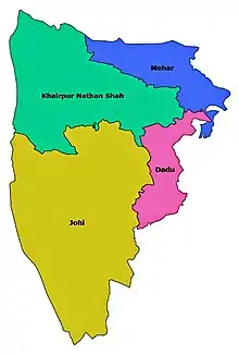
District Dadu has four tehsils, as tabulated below,:[10][11]
| Name | Population
1998 Census |
Population
2017 Census |
Number of
Union Councils |
|---|---|---|---|
| Dadu Tehsil | 327,972 | 460,481 | 15 |
| Johi Tehsil | 207,383 | 294,848 | 10 |
| Khairpur Nathan Shah | 253,309 | 334,258 | 12 |
| Mehar Tehsil | 318,053 | 460,679 | 15 |
The District has 14 Circles, 111 Tapa and 351 Dehs.
Places of interest
- Gorakh Hill - Hill station and the highest point in Sindh.[12]
- Manchar Lake - Largest fresh water lake in Pakistan.[13]
- Jamia Mosque (Khudabad) - the oldest mosques in Dadu
- Yar Muhammad Kalhoro Tomb
- Ghazi Shah Mound
- Ancient graves in Wahi Pandhi
- Ali Murad Mound
- Ancient Rock Carvings of Sindh
- Thul Hairo Khan
- Nai Gaj
- Nai Gaj Dam
- Necropolis of Mian Nasir Muhammad Kalhoro
- Cemetery of Mir Allahyar Talpur
- Shiva Mandir Johi
List of Dehs
The following is a list of Dadu District's 351 dehs, organised by taluka:[14]
Dadu taluka (67 dehs)
- Aminiani
- Badani
- Baghban
- Bakhrani
- Belo Choi
- Bhand
- Buth Malho
- Buthi
- Chanrath Jagir
- Chanrath Rayaeti
- Choi
- Dadu
- Dawichh
- Dhoro Damrio
- Duabo
- Dubi jagir
- Dubi Rayeti
- Ghallo
- Jakhpari
- Juberji
- Jung
- Kalhora
- Kandi
- Katcho Chanrath
- Katcho Kharero
- Katcho Nasrani
- Katcho Pumbi
- Katcho Purano Dero
- Katcho Rap
- Katcho Sita
- Keenjhar
- Khariro
- Khasa chandia
- Khero
- Khudabad Jagir
- Khudabad Rayaeti
- Khushik
- Koorpur
- Makhdoom Sahib
- Malkani
- Markhpur
- Marvi
- Moundar
- Nasrani
- Naulakho
- Noorja
- Pacco Sita
- Palha
- Pat
- Phaka
- Piperpanjan
- Pipri
- Pir gunio
- Pir Tarho Jagir
- Pir Tarho Rayeti
- Pumbi
- Purano Dero
- Rap
- Samheen
- Shahani
- Sial
- Sidhwah
- Sonnhion jagir
- Soonhion Rayeti
- Sutcharo
- Taga
- Warayaso
Johi taluka (110 dehs)
- Abad
- Allah Yar Dero
- Angi
- Aroni
- Arraro
- Baghari
- Bahwalpur
- Bakhar Shaheed
- Beer Bughio
- Bhashim Faqeer
- Bhlali Shah
- Bueer
- Buthi
- Chakar Kot
- Channa
- Chinni
- Cookrani
- Dabhari
- Dara Machhi
- Daubo
- Dhonk
- Din Panah
- Dohari Kunari
- Drigh Bala
- Drigh Henthi
- Fhero Dero
- Gahi Charo
- Gaji Khan
- Ghaha
- Gorandi
- Hairo Khan
- Haji Khan
- Hali Jo
- Hassnani
- Jalab
- Jampur Landki
- Jampur Panwarki
- Jhalko
- Johi
- Kathya Barani
- Keti Nai
- Khan Wah
- Khandhani
- Kharach
- Khat
- Khooh Mano
- Koor Kalan
- Koor Phajo
- Koorja Mikk
- Kot Bajo
- Lalhar
- Landho Dero
- Lohri
- Machoko
- Main-Ji-Kandi
- Makhan Belo
- Malhar Barani
- Malko Jagir
- Masoo Dero
- Mir Wah
- Mirani Mchhi
- Mothri
- Mureed Dero
- Nai Taki
- Naichki
- Nali
- Naushahro
- Noonari
- Nooro
- Pahore
- Pai
- Pat Gul Mohammad
- Pat Khanhari
- Pat Suleman-1
- Pat Suleman-2
- Pat Suleman-3
- Pat Suleman-4
- Patro-1
- Patro-2
- Patro-3
- Peer Dohari
- Phadak
- Phulji jagir
- Phulji Rati
- Pir Gaji Shah
- Potho
- Qasbo
- Qubo Qalandar-1
- Qubo Qalandar-2
- Rajo Dero
- Sakaro
- Sakir Hali Jo
- Saranjhari
- Sawaro
- Shah Hassan
- Shahdman
- Shahmorio
- Shori Jagir
- Sole Jagir
- Suk Nai
- Thariri Jado Shaheed
- Thull
- Tok Qasim
- Tore
- Tori
- Tori-1
- Tori-2
- Vigji Jgir
- Vigji Rati
- Wahi Pandhi
Khairpur Nathan Shah taluka (94 dehs)
- Abad Jagir
- Ahori Jagir
- Ahori Rayati
- Akhir Nari
- Bahadurpur
- Baid
- Baledera Jagir
- Baledera Rayati
- Banbhinyoon
- Bawan
- Bego dero
- Bhagna
- Bhangar
- Bori no. 1
- Bori no. 2
- Borriri
- Bugg
- Burrira Jagir
- Burrira Rayati
- Buttra
- Chhandan
- Chija pur Jagir
- Chija pur rayati
- Chow Khandi
- Dangar
- Dhingano
- Dogar
- Drib Toolan
- Dur Mohammad
- Fateh Pur
- Fekhirato
- Gabariji
- Gachal
- Gadhi
- Gharo
- Ghija pur Jagir
- Ghija pur rayati
- Gozo
- Isso Machi
- Isso Narejo Jagir
- Isso narejo Rayati
- Jakhiro
- Kakar
- Kande chukhi
- Kario Ghulam-ullah
- Kario Mitho Zangejo Jagir
- Kario Mitho Zangejo Rayati
- Khadhar
- Khairpur Jagir
- Khanbhan Nangin
- Khanpur
- Khariro kinaro
- Khat Lashikar
- Khathri
- Khurbi No. 1
- Khurbi No. 2
- Kooh Misri
- Koor budho
- Koor Hussain
- Kurkut Jagir
- Kurkut rayati
- Ladho Dero
- Mado Jagir
- Mado Rayati
- Maha
- Makhi Servey
- Makhi Unsurvey
- Malam No. 1
- Malam No. 2
- Mari
- Mir Mohammad
- Miro Kalhoro
- Pai
- Pai jaho
- Pusia
- Qamber Jagir
- Qamber Rayati
- Qomicharo
- Rahuja
- Rap
- Rap Kainchi
- Redhi Servey
- Redhi Unservey
- Salari No. 1
- Salari No. 2
- Salari No. 3
- Salari No. 4
- Salari No. 5
- Seer Abad
- Sheeh werho
- Sukhapur
- Thalho
- Vaiji
- Wasai
Mehar taluka (80 dehs)
- Abad-1
- Abad-11
- Anbar
- Bachi Jagir
- Bachi Rayeti
- Baledai
- Balko
- Band Garhi
- Belo Bhorti
- Belo Sona Bindi
- Betto
- Bhand Mari
- Bhorti-11
- Bhutto
- Bisharat katchri
- Bothro
- Butt Serai
- Charo
- Chhalo
- Dadh Barani
- Dadhar
- Dakhani
- Durbo
- Faridabad
- Faridabad Barani
- Gahi Maheasr
- Ganja Thorha
- Garkan
- Ghari Jageer
- Ghari rayeti
- Goongo
- Gul Mohd Wah
- Gunhero
- Humbar
- Kamalpur
- Kamangar
- Kandhra
- Kario Qasim Shah
- Kaseero
- Kawanjhro
- Keriro
- Khondi
- Kinaro Kakol
- Kolachi
- Kothi Khokhar
- Kothi Sodhari
- Kundan
- Lakhyari
- Laloo Ghari
- Langhano
- Litan
- Magsi
- Mangwani
- Manjan
- Mojhar Barani
- Mureed Lakhiar
- Nari
- Nasoi
- Nath
- Naun Goth
- Neerah
- Pat Kandi
- Pateji
- Peroz Shah
- Pipri
- Poarcho
- Radhan
- Rap Nari
- Reo Katcho
- Rojhan
- Roni
- Sadhar Aliwal
- Saeedpur
- Seri
- Shah Panjo
- Thariri Muhabat
- Umedero
- Ustelo
- Wah Gahi
- Waryaso
Notes
- ↑ Dadu, Johi, Kakar and Mehar talukas of Dadu district
- ↑ Including Jainism, Buddhism, Zoroastrianism, Judaism, Sikhism, Christianity, Ad-Dharmis, or not stated
References
- 1 2 "TABLE 1 : HOUSEHOLDS, POPULATION, HOUSEHOLD SIZE AND ANNUAL GROWTH RATE" (PDF). www.pbscensus.gov.pk. Pakistan Bureau of Statistics. 2023.
- ↑ "About Dadu". hotfm.com.pk. Retrieved 2019-08-11.
- ↑ "District Courts of Sindh". www.districtcourtssindh.gos.pk. Retrieved 2019-08-11.
- ↑ "Shaheed Mohtarma Benazir Bhutto Campus Dadu". Archived from the original on 2014-07-19. Retrieved 2016-03-06.
- ↑ "Four new districts created in Sindh". 2004. Retrieved 26 December 2016.
- ↑ "Dadu district uc list mna mpa seats".
- ↑ "Population by administrative units 1951-1998" (PDF). Pakistan Bureau of Statistics.
- 1 2 3 4 "District Wise Results / Tables (Census - 2017)". www.pbscensus.gov.pk. Pakistan Bureau of Statistics.
- ↑ "CENSUS OF INDIA, 1941 VOLUME XII SINDH PROVINCE" (PDF).
- ↑ "Pakistan: Tehsils and Talukas (Districts and Subdistricts) - Population Statistics, Charts and Map". www.citypopulation.de. Retrieved 2020-02-23.
- ↑ "هنگامي امدادي سرگرمين جو منصوبو" (PDF). آفتن کان اڳواٽ بچاءُ ۽ انتظام ڪاريءَ وارو شعببو. 2011. Retrieved 2020-02-23.
- ↑ "Gorakh Hills Development Authority's inability to polish Sindh's best hill station is costing us millions in tourism revenue". 8 September 2021.
- ↑ "Indus River and Manchhar Lake". earthobservatory.nasa.gov. 2010-09-10. Retrieved 8 September 2021.
- ↑ "List of Dehs in Sindh" (PDF). Sindh Zameen. Retrieved 22 March 2021.
Bibliography
- 1998 District census report of Dadu. Census publication. Vol. 82. Islamabad: Population Census Organization, Statistics Division, Government of Pakistan. 2000.
Provincial capital: Karachi | ||
| Banbhore |  | |
| Hyderabad | ||
| Karachi | ||
| Larkana | ||
| Mirpur Khas | ||
| Sukkur | ||
| Shaheed Benazir Abad | ||