Diana | |
|---|---|
 Diana Location within the state of West Virginia  Diana Diana (the United States) | |
| Coordinates: 38°34′24″N 80°27′29″W / 38.57333°N 80.45806°W | |
| Country | United States |
| State | West Virginia |
| County | Webster |
| Time zone | UTC-5 (Eastern (EST)) |
| • Summer (DST) | UTC-4 (EDT) |
| ZIP code | 26217[1] |
| Area code(s) | 304 and 681 |
| GNIS feature ID | 1554299[2] |
Diana is an unincorporated community in Webster County, West Virginia, United States, along West Virginia Route 15 and the Right Fork of the Holly River.
References
- ↑ "Diana ZIP Code". zipdatamaps.com. 2022. Retrieved November 30, 2022.
- ↑ U.S. Geological Survey Geographic Names Information System: Diana, West Virginia
Municipalities and communities of Webster County, West Virginia, United States | ||
|---|---|---|
| Towns | 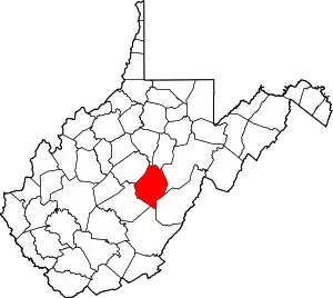 Map of West Virginia highlighting Webster County | |
| CDPs | ||
| Unincorporated communities |
| |
| Ghost towns | ||
This article is issued from Wikipedia. The text is licensed under Creative Commons - Attribution - Sharealike. Additional terms may apply for the media files.