Dolní Bělá | |
|---|---|
 Centre of Dolní Bělá | |
 Flag  Coat of arms | |
 Dolní Bělá Location in the Czech Republic | |
| Coordinates: 49°53′47″N 13°16′24″E / 49.89639°N 13.27333°E | |
| Country | |
| Region | Plzeň |
| District | Plzeň-North |
| First mentioned | 1318 |
| Area | |
| • Total | 2.15 km2 (0.83 sq mi) |
| Elevation | 460 m (1,510 ft) |
| Population (2023-01-01)[1] | |
| • Total | 466 |
| • Density | 220/km2 (560/sq mi) |
| Time zone | UTC+1 (CET) |
| • Summer (DST) | UTC+2 (CEST) |
| Postal code | 331 52 |
| Website | www |
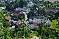
Dolní Bělá (Czech pronunciation: [ˈdolɲiː ˈbjɛlaː]) is a municipality and village in Plzeň-North District in the Plzeň Region of the Czech Republic. It has about 500 inhabitants.
Dolní Bělá is located approximately 18 kilometres (11 mi) north of Plzeň.
Sights
Dolní Bělá is known for the ruins of Bělá Castle. The castle was built before 1315. Parts of the castle walls are all that has survived to the present day, and the dry moats and ramparts are still visible in some places.[2]
The landmark of the village is the Church of Exaltation of the Holy Cross. It was built in the Empire style in 1822.[3]
Gallery
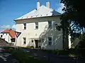 Municipal office
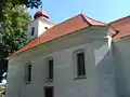 Church of Exaltation of the Holy Cross
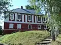 Rectory
References
- ↑ "Population of Municipalities – 1 January 2023". Czech Statistical Office. 2023-05-23.
- ↑ "Historie obce" (in Czech). Obec Dolní Bělá. Retrieved 2022-04-04.
- ↑ "Kostel Povýšení sv. Kříže" (in Czech). National Heritage Institute. Retrieved 2022-04-04.
External links
Wikimedia Commons has media related to Dolní Bělá.
This article is issued from Wikipedia. The text is licensed under Creative Commons - Attribution - Sharealike. Additional terms may apply for the media files.